Scroll to:
Role of strike-slips and graben-rifts in controlling oil and gas reservoirs in deep horizons of the Russko-Chaselsky Ridge (West Siberian Province)
https://doi.org/10.17073/2500-0632-2025-02-399
Abstract
The study of the geological setting features of the West Siberian Oil-and-Gas Province (OGP) is relevant for establishing the relationship between the spatial distribution of local strike-slip dislocations (Russko-Chaselsky Ridge) and the structure of the regional Pai-Khoi-Altai shearing zone. The work aims to identify the regularities of hydrocarbon accumulations location associated with fault systems of this zone. The paper presents the results of studies aimed at assessing the nature of the Earth crust disturbance within the regional Pai-Khoi–Altai shearing zone and the prerequisites for the occurrence of hydrocarbon accumulations within it. A complex set of regional and detailed geophysical data, including 2D and 3D seismic surveys and digital models of gravity and magnetic fields, was used as a factual basis. Based on these materials, cross-sections and maps were drawn showing the structural features of the sedimentary cover and consolidated basement, and an analysis of the nature of the Earth crust disturbance within the shearing zone was performed. It was revealed that the disjunctive dislocations of the regional Pai-Khoi–Altai shearing zone have a characteristic morphology described by a right-lateral strike-slip (dextral) fault strain ellipsoid. Within the Russko-Chaselsky Ridge, patterns were identified in the manifestation of strike-slips and graben-rifts systems caused by the tectonic activity of the regional Pai-Khoi–Altai shear. The shearing zone, en echelon faulting, and associated Riedel shears constitute a single, hierarchically subordinate system of the upper Earth crust disturbance. It is characterized by the development of en echelon system of disturbance zones in the platform cover and the upper part of the consolidated basement, interpreted as Riedel shears of prevailing submeridional strike. Based on the interpretation of seismic cross-sections along the Riedel shears, "flower structures" extending from the Lower Cretaceous to the top of the Paleozoic were distinguished. Structures of this type, located within the West Siberian Oil-and-Gas Province and represented by dislocation systems, may act as drainage in further substantiation of the mechanisms of migration and accumulation of hydrocarbons.
Keywords
For citations:
Sekerina D.D., Saitgaleev M.M., Senchina N.P., Glazunov V.V., Kalinin D.F., Kozlov M.P., Ismagilova E.I. Role of strike-slips and graben-rifts in controlling oil and gas reservoirs in deep horizons of the Russko-Chaselsky Ridge (West Siberian Province). Mining Science and Technology (Russia). 2025;10(2):109-117. https://doi.org/10.17073/2500-0632-2025-02-399
Role of strike-slips and graben-rifts
in controlling oil and gas reservoirs
in deep horizons of the Russko-Chaselsky Ridge
(West Siberian Province)
Introduction
We examined the geological setting features of the West Siberian Oil-and-Gas Province (OGP) in order to establish the relationship between the spatial distribution of local strike-slip dislocations (within the Russko-Chaselsky Ridge) and the dislocation system of the regional shearing zone in connection with the study of the regularities governing the location of hydrocarbon accumulations associated with a complex system of disjunctive dislocations that are part of the regional Pai-Khoi-Altai shearing zone [1, 2].
Within the West Siberian OGP, the bulk of the identified hydrocarbon accumulations [3–5] are confined to Cretaceous sediments. The Bazhenovsky horizon is considered to be the oil source strata; the Lower Cretaceous terrigenous rocks act as the reservoir; the Podachimovsky horizon mudstone is the impermeable layer [6–8]. The mechanism of hydrocarbon migration can be largely explained by the development of a system of disjunctive dislocations. Many researchers studied the nature of shear dislocations in consolidated basements and the lower parts of the sedimentary cover of the West Siberian geosyncline [9, 10]. For instance, A.E. Kontorovich distinguished between major shear dislocations of different directions (first order) penetrating into the Lower Cretaceous horizons and secondary shears (second order) mapped in the Cenozoic sequence [3, 11, 12].
A.I. Timurziev, based on an in-depth study of the 2D and 3D seismic survey data, concluded that regional shearing zones are widely manifested in the northwestern part of the West Siberian geosyncline [2, 9]. The author notes that the results of the 2D seismic surveys do not always accurately reflect horizontal shear structures (strike-slips), unlike the results of the detailed 3D seismic surveys [11, 13]. An important feature of the shears, in his view, is the almost complete absence of vertical displacements at the level of the uppermost consolidated basement.
Detailed studies within the Ety-Purovsky accumulation have shown that regional shears are framed by a system of en echelon tension stress and shearing dislocations. Within the shearing zones, based on the 3D seismic data, the author has identified a system of northwestward strike-slips and en echelon northeastward strike-slips on the sides and in the spaces separating the major strike-slips [9–13].
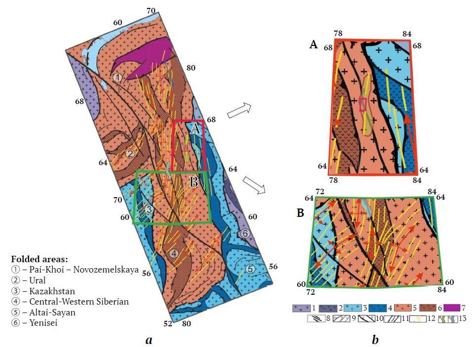
In our research, we considered the features of the deep structure of the regional Pai-Khoi–Altai shearing zone, which, judging by a complex of geological and geophysical data, extends from the Altai-Sayan folded area to the Pai-Khoi. The zone includes the main fault (geosuture) and a system of en echelon extension faults and strike-slips (shears) [14, 15] (Fig. 1). This system of tectonic dislocations developed against the backdrop of a consolidated basement formed by formations of different age, from the Yenisei (Baikalides), Kazakhstan and Altai-Sayan (Caledonides), Ural and Central-Western Siberian (Hercinides) folded areas [14].

Fig. 1. Fragment of a map of the deep geological setting of the consolidated basement of the West Siberian OGP with the location of the study area (A), the territory of the Russko-Chaselsky Ridge,
and with the outline of the neighboring area (B), within which the Ety-Purovsky Ridge is located [15]:
1–7 – structural and material subdivisions of the consolidated crust: 1–2 – Epibaykal folded areas (1 – blocks, 2 – interblock zones), 3–4 – Epicaledonian folded areas (3 – blocks, 4 – interblock zones), 5–6 – epihercinian folded areas (5 – blocks, 6 – interblock zones), 7 – ancient platforms;
8–11 – disjunctive dislocations: 8 – the Pai-Khoi–Novozemelsky shear displacement direction, 9 – en echelon disjunctive dislocations, 10 – boundaries of interblock suture zones, 11 – rift boundaries, 12 – lineaments and rift development direction, 13 – Ridge outlines (a – Russko-Chaselsky, b – Eti-Purovsky)
Research techniques and factual material
The area of our detailed research (Fig. 1, a), including the outline of the Russko-Chaselsky Ridge, is characterized by a high level of geological and geophysical knowledge [16]. As a factual basis for the research, we used the results of seismic surveys, deep drilling data, and potential geophysical fields data borrowed from the Gravimag database at a scale of 1 : 200,000 [16, 17].
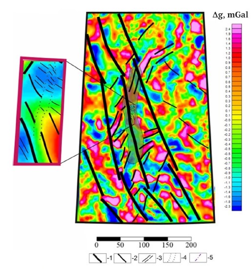
The study area at local level was selected depending on the seismic cross-section outlines. To simulate shear dislocations and investigate the structure of the basement and sedimentary cover within the study area, we performed a series of procedures: calculation of potential field transformants [18], including factorization into regional and local components, calculation of gradients, etc. [19, 20]. To estimate the amplitudes of tectonic deformations, seismic cross-sections were filtered using surface-consistent procedures, adaptive noise suppression, 5D regularization, and Kirchhoff depth migration (using OVT panels), as well as post-processing1 [21]. In addition, the results of solving inverse problems of gravity and magnetic surveys, etc. were used (Fig. 2) [21]. The methodological approach involved applying a multi-level data processing scheme at regional and local levels to identify characteristic patterns of subordination of geological structures.

Fig. 2. Results of interpretation based on potential fields (according to the map of the local component of the gravitational field) [compiled by the authors]:
1 – boundaries of rift structures (I rank); 2 – strike-slip; 3 – rift structures (II rank); 4 – presumed boundaries of Riedel shear development zone; 5 – axial direction of Riedel shear development
A. I. Timurziev found similar horizontal shear structures (strike-slips) are manifested in the sedimentary cover by linear en echelon systems of downthrow faults and thrust faults; the en echelon faults are grouped into a linear zone of NW strike (310–320°) with a width ranging from 1.0–1.5 km in the lower part of the sedimentary cover to 5.0–6.5 km in the Upper Cretaceous top. Along the strike, the suture zone comprises grabens and depressions of shear extension [9, 22].
A qualitative interpretation of the transformants [18, 23] allowed to identifying elongated positive anomalies of the gravitational and magnetic fields of submeridional strike in the central part of the detailed study area, which, in our opinion, are manifestations of rift structures [23–25]. On the structural-tectonic diagrams compiled based on these data (see Fig. 2), first-order shear dislocations (strike-slips) have a predominantly northwestern strike, while second-order rift structures are oriented northeastward and located in the space between the major shear dislocations [23, 26, 27].
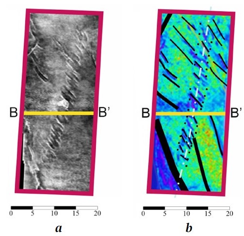
The manifestations of these dislocations at a detailed level in seismic cross-sections of the Bazhenovsky reflective horizon interval (Fig. 3) are expressed in graben-rift structures, traced in the form of “Riedel shears” oriented at an angle of 30° to the main shear axis [28, 29].

Fig. 3. Interpretation within the detailed study area with the position of seismic profile B–B’ (highlighted in yellow), performed on the basis of a horizontal cross-section of the total 3D cube in the interval of the Bazhenovsky reflective horizon (characteristic dimensions of kilometers) – a, and the amplitude distribution diagram along the seismic cross-section – b [compiled by the authors]

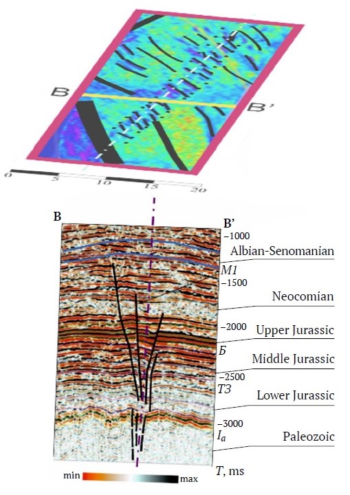
Fig. 4. The manifestation of the “flower structure” and Riedel shears based on seismic data interpretation (see legend to Fig. 2) [compiled by the authors]
According to most researchers, the main shear dislocations are deeply seated [30, 31]. The extension structures are most likely seated near the surface [32]. In this regard, we studied geological and geophysical cross-sections based on reference seismic profiles [11, 15]. In the interval between 1,000 and 2,000 ms, a system of disjunctive dislocations with a characteristic "flower structure" morphology can be traced (Fig. 4) [14]. Above this interval, only anticline folds are manifested that indirectly confirms the assumption of an attenuation of tectonic deformations in the Upper Jurassic sediments [31, 33].
The Figure demonstrates the strike-slips joining en echelon the plane of major shear in a fan-like manner [1, 34]. The appearance of the “flower structures” indicates the strike-slips (shears) of northeastern strike [35, 36] that allows assuming trans-tensional nature of the strike-slips [13, 34]. The roots of these faults can be traced below the uppermost basement (below 6 km) [37, 38].
The results obtained confirm that the manifestation of rifts and strike-slips in the form of Riedel shears creates favorable conditions for the migration and accumulation of hydrocarbons in traps [39]. For example, Riedel shears can serve as channels for hydrocarbon migration and also change the mechanical properties of rocks that in turn affects their ability to retain oil and gas and characterize the novelty of the authors’ research [2, 40].
The practical application of the results obtained lies in the use of structural factors (Riedel shears, “flower structure”) in solving predictive problems using both geophysical and geological-structural criteria for determining oil and gas potential.
1 Kadyrov R.I. Basin analysis and modeling of oil-and-gas-bearing systems. Kazan: Kazan (Volga Region) Federal University Publ.; 2020, 33 p. (In Russ.)
Conclusion (findings)
Thus, it can be concluded that the disjunctive dislocations of the regional Pai-Khoi–Altai shearing zone have a characteristic morphology described by a right-lateral strike-slip (dextral) fault strain ellipsoid. The shearing zone, en echelon faulting, and associated Riedel shears constitute a single, hierarchically subordinate system of the upper Earth crust disturbance and are promising for further study of hydrocarbon migration and accumulation mechanisms [5].
Within the Russko-Chaselsky Ridge, patterns were revealed in the manifestation of strike-slips and graben-rifts systems caused by the tectonic activity of the regional Pai-Khoi–Altai shear; This zone is characterized by the development of en echelon system of disturbance zones in the platform cover and the upper part of the consolidated basement, interpreted as Riedel shears of prevailing submeridional strike. The main shearing zone within the study area is 6 km long and 0.8 km wide. In the cross-section, an interconnection between disjunctive dislocations can be traced, in the distribution of which a “flower structure” can be identified, extending from the Lower Cretaceous to the uppermost Paleozoic and demonstrating a fan-shaped orientation of faults (within the studied area).
Structures of this type, located within the West Siberian Oil-and-Gas Province and represented by dislocation systems, may be considered as drainage in further substantiation of the mechanisms of migration and accumulation of hydrocarbons.
References
1. Timurziev A. I. Mechanism and structures of hidden explosive discharge of deep fluids in the basement and upper part of the Earth's crust. In: Hydrocarbon potential of basement of young and ancient platforms. Prospects of basement petroleum potential and evaluation of its role in formation and reformation of oil and gas fields: proceedings of the International Scientific Conference. Kazan: Kazan University Press; 2006. Pp. 262–268. (In Russ.)
2. Timurziyev A. I. New paradigm of oil and gas geology based on deep filtration model of fluid formation and accumulation. Journal of Geophysics. 2007;(4):49–60. (In Russ.)
3. Western Siberia. In: Geology and mineral resources of Russia. In 6 volumes. Vol. 2. Chief editor: Orlov V. P. Volume eds.: Kontorovich A. E., Surkov V. S. St. Petersburg: VSEGEI Publ. House; 2000. 477 p.
4. Fomin S. I., Govorov A. S. Strategy of formation of operating space in open
5. pit mines based on cut-off grade control. Mining Informational and Analytical Bulletin. 2024;(11):165–179. (In Russ.) http://doi.org/10.25018/0236_1493_2024_11_0_165
6. Lebedeva E. A., Faibusovich Ya. E., Nazarov D. V. et al. State geological map of the Russian Federation scale 1 : 1,000,000. Third generation. West Siberian series. Sheet Q-44 – Tazovsky. Explanatory note. Ministry of Natural Resources of Russia, Rosnedra, FGBU "VSEGEI". St. Petersburg: VSEGEI Publishing House; 2020. 191 p. (In Russ.)
7. Kontorovich A. E., Lotyshev V. I., Melnikov N. V. et al. Petroleum potential of Siberian platform regions. Otechestvennaya Geologiya. 2008;(2):85–96. (In Russ.)
8. Surkov V. S., Trofimuk А. А., Zhero О. G. Triassic rift system in the west Siberian plate and its bearing on the structure and petroleum potential of the platform Mesozoic-Cenozoic cover. Geologiya i Geofizika. 1982;(8):3–15. (In Russ.)
9. Nefedov Yu., Gribanov D., Gasimov E. et al. Development of Achimov deposits sedimentation model of one of the West Siberian oil and gas province fields. Reliability: Theory & Applications. 2023;(SI 5):441–448. https://doi.org/10.24412/1932-2321-2023-575-441-448
10. Gogonenkov G. N., Kashik A. S., Timursiyev A. I. Horizontal displacements of west Siberia's basement. Geologiya i Geofizika. 2007;(3):3–10. (In Russ.)
11. Gogonenkov G. N., Timurziev A. I. Strike-slip faults in the West Siberian basin: implications for petroleum exploration and development. Russian Geology and Geophysics. 2010;51(3):304–316. https://doi.org/10.1016/j.rgg.2010.02.007 (Orig. ver.: Gogonenkov G. N., Timurziev A. I. Strike-slip faults in the West Siberian basin: implications for petroleum exploration and development. Geologiya i Geofizika. 2010;(3):384–400. (In Russ.))
12. Gorelik G. D., Egorov A. S., Shuklin I. A., Ushakov D. E. Substantiation of optimal range of geophysical surveys to study deep structure of the Lake Vostok area. Gornyi Zhurnal. 2024;(9):56–61. (In Russ.) https://doi.org/10.17580/gzh.2024.09.09
13. Prishchepa O.M., Lutskii D.S., Kireev S.B., Sinitsa N.V. Thermodynamic modelling as a basis for forecasting phase states of hydrocarbon fluids at great and super-great depths. Journal of Mining Institute. 2024;269:815–832.
14. Timurziev A. I. The Neotectonic shear tectonics of sedimentary basins: tectonophysical and fluid dynamics aspects (in connection with an oil-and-gas-bearing capacity). Part 1. Glubinnaya Neft'. 2013;(4):561–605. (In Russ.)
15. Egorov A. S. Deep structure and composition characteristics of the continental earth’s crust geostructures on the Russian Federation territory. Journal of Mining Institute. 2015;216:13–30. (In Russ.)
16. Egorov A. S., Antonchik V. I. , Senchina N. P. et al. Impact of the regional Pai-Khoi-Altai strike-slip zone on the localization of hydrocarbon fields in Pre-Jurassic Units of West Siberia. Minerals. 2023;13(12):1511. https://doi.org/10.3390/min13121511
17. Lebedeva E. A. State Geological Map of the Russian Federation. Third generation. Map of pre-Quaternary formations: Q-44 (Tazovsky). Geological map of pre-Quaternary formations. West Siberian series, scale: 1 : 1,000,000, series: West Siberian. Compiled by: FGBU "VSEGEI"; 2020.
18. Makeev S. M., Anufriev A. E. Gravity-structural maps as new tool to analyse the Siberian Platform bedded-block structure. Geology and mineral resources of Siberia. 2015;(1):69–77. (In Russ.)
19. Yakovleva A. A., Movchan I. B., Medinskaya D. K., Sadykova Z. I. Quantitative interpretations of potential fields: from parametric recalculations to geostructural ones. Bulletin of the Tomsk Polytechnic University. Geo Assets Engineering. 2023;(11):198–215. (In Russ.) https://doi.org/10.18799/24131830/2023/11/4152
20. Cochran J. R., Karner G. D. Constraints on the deformation and rupturing of continental lithosphere of the Red Sea: The transition from rifting to drifting. Geological Society. 2007;262:265–289. https://doi.org/10.1144/sp282.13
21. Talovina I. V., Mangal F., Smuk G. V., Krikun N. S. Geological and geophysical data interpretation for deep structure study of the Kabul Massif. Gornyi Zhurnal. 2024;(9):68–77. (In Russ.) https://doi.org/10.17580/gzh.2024.09.11
22. Khalyulin I. I., Shelikhov A. P., Yaitsky N. N. Analysis of the relationship between potential field anomalies and the structural framework of the sedimentary cover. In: Issues of theory and practice of geological interpretation of geophysical fields: proceedings of the 47th session of the International Scientific Seminar of D. G. Uspensky – V. N. Strakhov. Voronezh, 27–30 January 2020. Voronezh: Nauchnaya Kniga Publ. Center; 2020. P. 288–290. (In Russ.)
23. Kulikov P. K., Belousov A. P., Latypov A. A. West Siberian Triassic rift system. Geotektonika. 1972;(6):79–87. (In Russ.)
24. Smirnov O. A., Borodkin V. N., Lukashov A. V. et al. Regional model of riftogenesis and structural-tectonic area of the north of Western Siberia and the South Kara Syneclise on the geological-geophysical research data. Petroleum Geology. Theoretical and Applied Studies. 2022;(1):1–18. https://doi.org/10.17353/2070-5379/1_2022
25. Kharakhinov V. V. Ancient rifts of Eastern Siberia and their petroleum potential. Russian Oil and Gas Geology. 2016;(4):3–17. (In Russ.)
26. Vinogradov Y. I., Khokhlov S. V., Zigangirov R. R. et al. Optimization of specific energy consumption for rock crushing by explosion at deposits with complex geological structure. Journal of Mining Institute. 2024;266:231–245.
27. Surkov V. S., Smirnov L. V. Geology and petroleum potential of the West-Siberian plate basement. Otechestvennaya Geologiya. 2003;(1):10–16.
28. Magoarou C. L., Hirsch K., Fleury C. Integration of gravity, magnetic, and seismic data for subsalt modeling in the Northern Red Sea. Interpretation. 2021;(9):507–521. https://doi.org/10.1190/int-2019-0232.1
29. Abdelfettah Y., Calvo M. Using highly accurate land gravity and 3D geologic modeling to discriminate potential geothermal areas: Application to the Upper Rhine Graben, France. Geophysics. 2019;(2): 1MA–Z8. https://doi.org/10.1190/geo2019-0042.1
30. Kontorovich A. E., Burshtein L. M., Gubin I. A. et al. Deep-buried Lower Paleozoic oil and gas systems in eastern Siberian Platform: geological and geophysical characteristics, estimation of hydrocarbon resources. Journal of Mining Institute. 2024;269:721–737.
31. Yanis M., Marwan N. Ismail Efficient Use of Satellite Gravity Anomalies for mapping the Great Sumatran Fault in Aceh Province. Indonesian Journal of Applied Physics. 2019;(2):61–67. https://doi.org/10.13057/ijap.v9i2.34479
32. Gurari F.G., Devyatov V.P., Demin V.I. et al. Geological structure and petroleum potential of the lower-middle Jurassic in the West Siberian Province. Novosibirsk: Nauka; 2005. 156 p. (In Russ.)
33. Novikov I. S., Zhimulev F. I., Pospeeva E. V. Neotectonic fault pattern of the Salair area (Southern West Siberia): relation with the pre-Cenozoic tectonic framework. Russian Geology and Geophysics. 2022;63(1):1–12. http://doi.org/10.2113/RGG20204257 (Orig. ver.: Novikov I. S., Zhimulev F. I., Pospeeva E. V. Neotectonic fault pattern of the Salair area (Southern West Siberia): relation with the pre-Cenozoic tectonic framework. Geologiya i Geofizika. 2022;(1):3–19. (In Russ.) http://doi.org/10.15372/GiG2021113
34. Prischepa O. M., Sinitsa N.V. Prospects for Oil and Gas Bearing Potential of Paleozoic Basement of West Siberian Sedimentary Basin. International Journal of Engineering. 2025;38(05):1098–1107. https://doi.org/10.5829/ije.2025.38.05b.12
35. Znamensky S. E. The positive flower structure of the Yalchigulovsky fault in the Southern Urals. 2019;(2):24–31. Geologicheskii Vestnik. (In Russ.) http://doi.org/10.37539/230224.2023.94.10.001
36. Dmitrievskiy A. N., Shuster V. L., Punanova S. A., Samoilova A. V. Modeling of geological structure and mechanisms of formation and distribution of oil and gas accumulations in pre-Jurassic complexes of Western Siberia. Moscow: IPNG RAN; 2007. 20 p. (In Russ.)
37. Talovina I. V., Ilalova R. K., Babenko I. A. Platinum group elements as geochemical indicators in the study of oil polygenesis. Journal of Mining Institute. 2024;269:833–847.
38. Shi W., Mitchell N. C., Kalnins L. M., Izzeldin A. Y. Oceanic-like axial crustal high in the central Red Sea. Tectonophysics. 2018;747–748:327–342, https://doi.org/10.1016/j.tecto.2018.10.011.
39. Fossen H. Structural Geology. Cambridge University Press; 2016. 2036 p.
40. McClay K., Bonora M. Analog models of restraining stepovers in strike-slip fault systems. American Association of Petroleum Geologists Bulletin. 2001;85(2):233–260. https://doi.org/10.1306/8626c7ad-173b-11d7-8645000102c1865d
About the Authors
D. D. SekerinaEmpress Catherine II Saint Petersburg Mining University
Russian Federation
Daria D. Sekerina – Cand. (Geol.-Miner.), Assistant Professor of the Department of Geophysics
Saint Petersburg
Scopus ID 57221599365
M. M. Saitgaleev
Russian Federation
Malik M. Saitgaleev – PhD-Student of the Department of Geophysics
Saint Petersburg
Scopus ID 57210747223
N. P. Senchina
Empress Catherine II Saint Petersburg Mining University
Russian Federation
Natalia P. Senchina – Cand. (Geol.-Miner.), Assistant Professor of the Department of Geophysics
Saint Petersburg
Scopus ID 56401906000
V. V. Glazunov
Empress Catherine II Saint Petersburg Mining University
Russian Federation
Vladimir V. Glazunov – Dr. Sci. (Eng.), Professor of the Department of Geophysics
Saint Petersburg
Scopus ID 57195385942
D. F. Kalinin
Empress Catherine II Saint Petersburg Mining University
Russian Federation
Dmitrii F. Kalinin – Dr. Sci. (Eng.), Professor of the Department of Geophysics
Saint Petersburg
Scopus ID 57668309500
M. P. Kozlov
Russian Federation
Mikhail P. Kozlov – Lead Geophysicist, Seismic Data Processing Department; PhD-Student of the Department of Geophysics
Ufa
E. I. Ismagilova
Russian Federation
Emilia I. Ismagilova – Student of the Department of Geophysics
Saint Petersburg
Supplementary files
Review
For citations:
Sekerina D.D., Saitgaleev M.M., Senchina N.P., Glazunov V.V., Kalinin D.F., Kozlov M.P., Ismagilova E.I. Role of strike-slips and graben-rifts in controlling oil and gas reservoirs in deep horizons of the Russko-Chaselsky Ridge (West Siberian Province). Mining Science and Technology (Russia). 2025;10(2):109-117. https://doi.org/10.17073/2500-0632-2025-02-399


