Scroll to:
Analysis of a digital terrain model for solving geological problems by the example of Aktogai ore field
https://doi.org/10.17073/2500-0632-2025-06-422
Abstract
The formation of terrain reflects a combination of geological processes, including tectonics, magmatism, and erosion. A digital terrain model (DTM) is an important tool for solving geological problems, including the prediction of ore deposits, especially in areas of low exploration maturity. The paper discusses the surface imprinting of geological processes that form a terrain, and also considers a method of digital terrain model analysis. The presented method allows identifying specific landforms similar to those formed above known deposits that makes it possible to add one more prospecting criterion when prospecting for porphyry deposits and deposits formed under similar conditions. The Aktogai ore field was selected as the object for studying the terrain above the known deposits. The Aktogai ore field is located in the northeastern part of Near-Balkhash territory. It includes two major porphyry copper deposits, Aktogai and Aidarly, a small copper deposit Kyzylkia, as well as a number of copper and polymetallic occurrences of porphyry and vein types associated with the Koldar granite massif of the "variegated batholith" formation. All objects identified within the Aktogai ore field were formed under specific structural conditions of ore formation and were affected by erosion processes to varying degrees. This, in turn, is expressed by the presence of local landforms of these objects on the day surface, which are characterized by different "terrain energy" factors. Analysis of the DTM surface allows not only to identify local landforms above an ore body and their morphological features, but also to indirectly assess the erosional truncation of the ore body. Based on morphological characteristics, it is also possible to classify host rocks lithological units. An assessment of the applicability of the method depending on the characteristics of an ore body and an indirect assessment of the tectonic conditions of deposit formation are provided. It has been established that large ore deposits (Aktogai, Aidarly, Zapadny Stockwork) manifest themselves in the terrain as local cauldron subsidences. These zones are characterized by a high degree of textural heterogeneity and coincide with areas of intense metasomatism. Areas morphologically and spectrally similar to the areas of known ore bodies have been identified, indicating their potential for further exploration. DTM and textural analysis methods allow identifying geological and structural features associated with porphyry systems and serve as an additional tool for predicting new ore bodies/deposits. The integration of morphometric (physiographic) and spectral analysis increases the reliability of the interpretation of geological processes.
Keywords
For citations:
Seib N., Belov Yu., Zimanovskaya N., Orazbekova G., Tretyakova A., Muratova A., Kassenov I. Analysis of a digital terrain model for solving geological problems by the example of Aktogai ore field. Mining Science and Technology (Russia). 2025;10(3):245-261. https://doi.org/10.17073/2500-0632-2025-06-422
Analysis of a digital terrain model for solving geological problems by the example of Aktogai ore field
Introduction
The analysis of physiographic structures is necessary for solving many geological problems. A present-day terrain is usually an indication, manifestation of several superimposed geological processes. The identification of individual landforms and analysis of their relative positions make it possible to establish the frequency of occurring geological processes/phenomena in a region. Accordingly, specific geological tasks involve identifying individual landforms: this includes identifying the outlines and structural positions of the objects under study, their relative location and scale of manifestation, as well as certain physiographic features, such as assessing erosion processes, which in turn indicate tectonic changes in the region. In some cases, it is necessary to distinguish regional terrain, while in others, local landforms need to be distinguished. A wealth of experience has been accumulated in recognizing and interpreting landforms to reconstruct various geological processes [1–3].
With the development of matrix electronic models of elevation surfaces and computer technologies, new opportunities for analysis have emerged [4–6]. Elevation matrices can be constructed using radar data, through reconstructing the terrain using stereoscopic pair images, or by obtaining elevation data using GPS and laser technologies. These methods are often combined and supplemented with information from various sources [7, 8]. The ability to use both absolute and relative elevation values allows not only for a qualitative assessment of objects, but also for a quantitative assessment of certain processes [9, 10].
The aim of this study is to develop a methodology for interpreting the geomorphological features of the formation and erosion of porphyry copper deposits based on a digital terrain model (DTM) and textural analysis, with the subsequent application of the findings to identify mineralization prospects using the Aktogai ore field as a reference example.
The study proposes using terrain parameters as an additional prospecting criterion for assessing the tectonic setting, the depth of the erosional truncation, and the spatial position of ore bodies relative to daylight surface. The novelty of the study lies in the integration of DTM analysis, textural characteristics, and satellite image classification data for a comprehensive forecast of metasomatic alteration zones and potential valuable mineralization.
In performing this study, we set the following tasks:
- Conducting a geological and structural analysis of the Aktogai ore field and justify its selection as a reference site for assessing the terrain above porphyry deposits
- Building and interpreting a digital terrain model (DTM) based on GeoEye-1 satellite data and other sources, identifying local depressions and residual surface
- Performing textural analysis of the terrain (including entropy, skewness, terrain energy, etc.) in order to identify structural and lithological nonuniformities
- Comparing the results of the terrain analysis with known areas of metasomatic alteration and ore stockworks, identifying relationships between terrain physiography and erosion depth
- Classifying spectral data to identify lithological units and secondary mineral halos, comparing with the results of the terrain analysis;
- Evaluating the informative value of each method and proposing an integrated approach to predicting prospects with signs of valuable mineralization.
The example below demonstrates the feasibility of using terrain analysis to solve geological problems. The study was carried out by the example of the Aktogai ore field, located in the Ayagoz district of the East Kazakhstan region. The basis is finding a background (regional) surface that simultaneously provides information about the regional terrain or relative to which it is possible to calculate the residual (remaining) surface for distinguishing local surface landforms and analyzing the textural features of the terrain.
1. Geological position and fundamentals
The Aktogai group of porphyry copper-molybdenum deposits, Aktogai, Aidarly, and Kyzylkya, are located northeast of Balkhash Lake in Eastern Kazakhstan, 450 km northeast of Almaty. Together, they have total resources of more than 3 billion tons of ore containing more than 10 million tons of copper and about 60 tons of gold.
There is a considerable interest in studying the patterns of porphyry mineralization in the Central Asian region. A body of research conducted in recent years reveals a clear pattern linking mineralization to specific regional structural and tectonic conditions. Based on the studies reconstructing the geological conditions in the region [11, 12], patterns in the distribution of known large porphyry copper systems in the Asian region were identified [13, 14].
Porphyry-epithermal mineral systems are mainly considered to form in magmatic arcs (both continental and oceanic) associated with active continental margins [15, 16]. The Aktogai ore field located on the active margin of the Balkhash-Ili volcanic-plutonic belt of the Kazakh-Mongolian magmatic arc and associated with the post-collision intrusive complex of the early Late Paleozoic (Fig. 1) [12] is no exception.
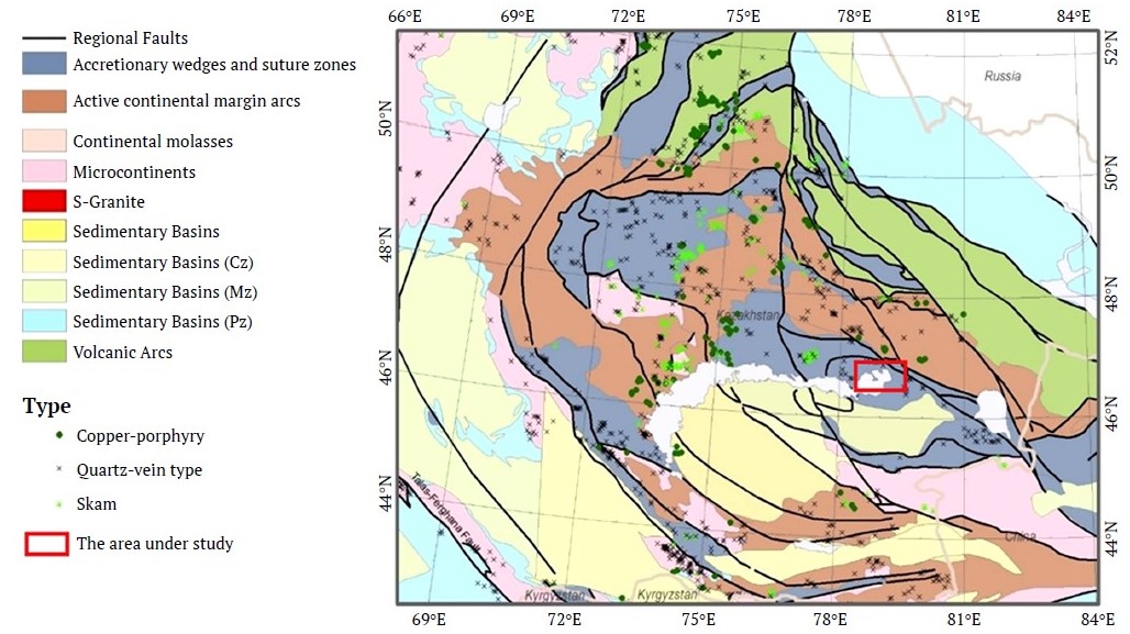
Fig. 1. Location of the study area on the geological map of the Balkhash-Dzungarian metallogenic province (modified from Windley et al., 2007)
It is assumed that in all cases, the deposits were formed at shallow crustal levels: <1.5 km for epithermal systems and <6 km for porphyry systems. Due to their shallow depth, the deposits are subject to relatively rapid erosion and have low conservation potential that explains why such geologically old (Paleozoic or older) deposits are rare. Mineralization formed in porphyry-epithermal mineral systems is usually spatially and temporally associated with intermediate and felsic subaerial volcanic rocks and corresponding subvolcanic intrusions.
The ore-forming intrusions of the Aktogai deposit were formed in an arc setting 331.4–327.5 million years ago as a result of partial melting of the thickened, eclogitized, and sulfide-rich juvenile lower crust [17]. The ore-bearing Koldar pluton formed in an arc setting 366–336 million years ago [18] during the collision of the Siberian Platform with the Kazakh continent and the Baltic-Ural block [19] and during the closure of the Dzungarian-Balkhash Sea [20]. The Koldar massif is considered to be comagmatic with the Keregetas volcanic complex, which formed in the late Carboniferous period.
The Koldar pluton, covering an area of 75 km², is a complex intrusion (Fig. 2) [21]. Three phases can be distinguished within the Koldar massif: 1 – gabbro-diorite, gabbro-diabase, melanocratic diorite, quartz diorite, granodiorite; 2 – batholith granite; 3 – porphyritic microgranite, granite-porphyry (probably marginal facies of the intrusion). The massif is predominantly represented by diorites and quartz diorites [22].
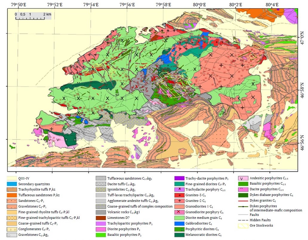
Fig. 2. Geological map of the Koldar massif (according to Sergiyko Yu.A. et al., 1980)
The three main deposits of the Aktogai ore field are associated with stock-like granodiorite and plagiogranite porphyries intruding the extensive Late Carboniferous Koldar laccolith-like massif [23], and with a large xenolith of Carboniferous rocks within the pluton. When intruding, the ore-forming intrusions caused significant hydrothermal alteration.
The cross-sections show layers of Middle-Upper Carboniferous volcanogenic-sedimentary rocks of the Keregetas series and Upper Carboniferous-Lower Permian Koldar series. The former series consists of andesite with a small amount of rhyolite, sandstone, and siltstone, while the latter includes sedimentary rocks, volcanogenic- sedimentary rocks, and a small amount of felsic tuff [18, 24].
1.1. Aktogai Deposit
The Aktogai deposit is located in the eastern part of the Central Aktogai Massif. This pluton, a porphyritic granodiorite body, intruded through the diorite, quartz diorite, and granodiorite of the Koldar pluton. The porphyritic granodiorite is cut by an elongated stock consisting of ore-bearing granodiorite and plagiogranite (tonalite) porphyries, accompanied by a series of chimney bodies of explosive breccias with quartz-biotite and sericite-tourmaline matrices, formed together with the porphyry intrusion. The magmatic complex's vein rocks represented by diorite and diabase porphyrites, quartz and dacite porphyries are not widespread. A special group is represented by small bodies and dykes of fine-grained matrix granodiorite-porphyry and glassy matrix granodiorite-porphyry, as well as large dyke-like granite bodies in the Aidarly area [25, 26].
The ore-bearing stockwork is located in the exocontact of a porphyry stockwork, forming a cone-shaped body that tapers downward and transits at depth into a series of linear west-northwestward mineralized zones. On the surface, the ore body has an elliptical ring shape, partially exposed to the west, with a maximum diameter of about 2,500 m and a radial width of 80 to 530 m [26]. The most recent vein formations, possibly already Permian, are represented by post-mineralization diabase and andesite porphyrites.
All rocks in the vicinity of the ore body area, except for late mafic dikes, were altered. The barren core of the cone consists of a siliceous zone composed of quartz bodies surrounded by a dense network of barren quartz veinlets and a thin zone of sericite-quartz alteration. At the margins, the silicified core changes into a dense zone of early potassium alteration, including potassium feldspar and biotite, which surrounds the main ring-shaped ore body. This potassium zone includes several linear intervals, which are weakly mineralized but heavily altered with feldspar and surrounded by a wide biotite halo. Phyllic alteration, characterized by the presence of quartz-(carbonate)-chlorite-sericite association, manifest itself in the form of irregular thin linear zones, confined to the contacts of granodiorite porphyry apophyses and fracturing zones along the flanks of the ore body. The periphery of the porphyry copper system is surrounded by a large propylite halo containing epidote-amphibole and albite-chlorite-prehnite. The mineralized system exhibits external zoning from bornite-chalcopyrite in the center to chalcopyrite-pyrite and pyrite halo in the outer parts. Copper and molybdenum overlap each other, while lead-zinc mineralization is limited to carbonatization zones on the sides of the ore body [27].
1.2. Aidarly deposit
The Aidarly deposit is located approximately 4 km northwest of the Aktogai deposit and lies within the same elongated 8×2 km sulfide alteration zone. It is concentrated on a small northwestern extension of ore-bringing granodiorite porphyry, which intruded into the diorite, quartz diorite, and granite phases of the Koldar pluton. The edge of the granodiorite porphyry has steep contacts characterized by numerous apophyses and is accompanied by a series of northeastward and northwestward fragmented dikes of the same composition. All these intrusions are cut through by late quartz diorites and dolerites. Small chimney breccia bodies in the vicinity of granodiorite porphyry consist of cemented fragments of mineralized rocks [27].
The mineralization is limited by the outer boundaries of the stock and the surrounding Koldar pluton and is closely associated with the stock. On the surface, the ore body is exposed in the form of an elongated northwestward ring, surrounding slightly mineralized granodiorite porphyry. Unlike Aktogai, the ore body resembles a downward-expanding cone with a barren core occupied by weakly mineralized granodiorite porphyry and a zone of silicification. The alteration and mineral zoning are similar to those described at Aktogai. The exposed granodiorite porphyry has undergone minor silicification and sericitization. At a depth of 600 m, the porphyry has a non-mineralized intensively silicified core with disseminated anhydrite at its outer edges. At the periphery of the porphyry system, silicification transits outward into a potassium alteration zone containing quartz-potassium feldspar-biotite. Higher up in the system, at medium and near-surface depths, a zone of phyllitization characterized by quartz-sericite-chlorite-carbonate association with rare tourmalinization is found. In turn, the potassium zone is surrounded by a wide halo of propylite alteration.
The Cu-Mo ore stockwork is confined to the early potassic zone, where sericitization is evident. Although most aspects of the mineralization and alteration at Aidarly are similar to those described above for Aktogai, the Aidarly deposit differs in that it has a more extensive and better developed zone of polymetallic (Pb-Zn) veins and veinlets on the outer margins. Comparisons show that the Aidarly deposit is less eroded than the Aktogai.
1.3. Kyzylkiya deposit
The small Kyzylkiya deposit is located 4 km east of the Aktogai deposit, on the opposite side of the Aidarly deposit (see Fig. 2). At the deposit, Cu-Mo mineralization is associated with a small stock of granodiorite porphyry intruding into the granodiorites of the Koldar pluton. Ore bodies are present as en-echelon zones of chalcocite-bornite-chalcopyrite ores, accompanied by uneven kalifeldsparization-silicification and sericitization [27]. The Kyzylkiya ore stockwork is characterized by lower sulfur content than at Aktogai and Aidarly, and, accordingly, weak pyritization and significantly lower amounts of supergene chalcocite and bornite. In terms of the morphology of ore bodies, the composition and nature of metasomatic alteration, the quality of ore mineralization, and their zoning, the Kyzylkiya deposit is comparable to the root parts of the Aktogai deposit1 that indicates deep erosion in the eastern part of the ore field.
The specific nature of metasomatic alteration at the Kyzylkiya deposit is observed. High-temperature amphibole-epidote facies propylites are developed in the form of narrow bands in the northwest and southeast of the stockwork. Medium-temperature albite-prehnite-chlorite propylites in the form of a semicircle frame the stockwork north-easterly and south-easterly2. The biotitization process at the deposit is very widespread. Quartz-kalifeldspath metasomatites with relics of the original rocks have been recorded in the south, southwest, and northwest (outside the ore stockwork). Slight kalifeldsparization is observed in the center of the ore stockwork and in the form of thin zones to the north and east beyond its boundaries. Quartz-sericite metasomatites are found only at the southern border of the ore stockwork, extending slightly beyond its limits. Argillization within the Kyzylkiya stockwork is manifested only in the southwest in the form of two narrow zones. Tourmalinization is widely manifested at the deposit, especially in its southwestern tip. Carbonatization covers almost the entire stockwork; zeolitization covers its northern part and is observed in separate patches in the south3. It should be noted that metasomatism leading to significant rock destruction (argillization, sericitization) is not very pronounced here.
The Aktogai and Aidarly deposits are confined to the Aktogai deep fault zone, while the Kyzylkiya deposit is confined to the parallel Ikbas fault zone. The sulfide mineralization total area is 26 km2. It has a slightly arched shape with the convex side facing south. The zone extends from west to east for about 14 km, with a width ranging from 1-1.5 to 3-3.5 km. The apparent polarizability of rocks in the anomalous zone varies from 4 to 26%.
Less significant IP anomalies are located 1-1.5 km north of the Aktogai deposit, at the same distance south of the deposit, and in the extreme southwest. Some of them correspond to small manifestations of porphyry copper formation.
1 Ivlev R. R. Volumetric geochemical zoning of porphyry copper systems and its practical significance. [PhD Thesis]. 1987.
2 Ibid.
3 Ibid.
1.4. Geological and lithological features affecting the terrain of porphyry deposits
The surface terrain reflects the tectonic and erosional processes occurring in a region. Assessment of the nonuniformity of the terrain, its texture, and the relative differences in erosion truncation, along with other methods, make it possible to characterize the features of the region [28, 29].
All porphyry copper deposits in Kazakhstan were formed more than 200–400 million years ago. Most of the oldest deposits were denuded as a result of repeated tectonic processes that occurred in the territory of present-day Kazakhstan. The terrain of preserved deposits turned out to be in near-surface conditions is determined not only by their original shape, but also by the lithological characteristics and wall-rock alteration of the deposits and host rocks.
1.5. Ore control structures
The formation of calderas is often associated with ore deposits, including porphyry copper, epithermal, polymetallic veins, and volcanogenic massive sulfide deposits [4]. Calderas often form above magmatic chambers because the magma inside a chamber is a large source of heat and magmatic volatiles that drive hydrothermal systems [30, 31] above magmatic chambers. As a result of heating, the rocks above a magmatic chamber undergo expansion and deformation, the nature of which depends on the heat source, the isotropy of the host medium, and the tectonic stresses that existed during the intrusion of magma into the Earth's crust. Subsequent structures are superimposed within the formed calderas, and despite the fact that over millions of years the originally formed calderas have been partially denuded and buried, their influence on the formation of the denudation terrain remains. In a relatively isotropic environment, radial and annular structures can be expected to form as magma cools.
Systems of fractures, veins, and breccias are an inevitable consequence of porphyritic magmatism. As noted by Tosdal R. M. and Richards J. P. (Tosdal R. M., Richards J. P., 2001), porphyritic intrusions can be cork-shaped and in some cases associated with both steeply dipping radial fractures and gentle concentric fractures reflecting stress conditions dominated by magma, where the two main horizontal stresses are almost equal that, in turn, affects the formation of the terrain above eroded porphyry systems.
Numerous examples of concentric and radial fracture systems are known in Climax-type rhyolite and porphyry deposits (molybdenum) [4, 32], but such fracture geometry is not characteristic of porphyry copper deposits. In conditions of differing horizontal stresses, subparallel dyke-like porphyry intrusions are more common [33-35]. Such conditions are more likely to reflect the stress regime in a remote area. Tabular veins and fractures ranging in size from centimeters to decimeters are characteristic of high-temperature potassium alteration zones [33, 34], but may extend to the near-surface fully developed argillitization zone. Veins D (with sericite halos) tend to be wider, more continuous, more widely spaced, and more variable in strike and dip than the earlier higher-temperature tabular veins. In some cases, they are radial [35, 36]. In some areas, such veins occupy groups of conjugated faults with minor (from meters to tens of meters) shear and normal displacements, which are concentrated on the porphyry hydrothermal system but can extend several kilometers laterally. The Main Stage veins in Butte (“Copper City”, Montana, USA) extend 10 km from east to west and follow two types of faults that indicate minor compression from east to west and expansion from north to south [4].
The main structures are formed in the tension zones. Fracture systems drain ore fluids from magmatic source rocks at depth to higher levels of the Earth's crust (both epithermal and porphyry), where mineral deposition occurs, while epithermal fluids evolve during upward migration. Permeable fractures form the geometry of ore stocks. Synmineral structures displace ore systems. Post-mineral structural shears also affect the geometry of the ore system and require analysis during the exploration of displaced ores.
The resulting ore deposits may be located at different levels of the Earth's crust between a magmatic chamber and the surface. The most suitable conditions for the ascent of heated volatile substances to shallower levels of the Earth's crust occur along preferred permeable zones, such as existing regional structures (faults) or, more commonly, caldera structures. On the one hand, tension stresses above magmatic sources, destruction, and fragmentation of rocks create cauldron subsidence landforms; on the other hand, fluids flow along existing structures resulting in the superimposition of structures and the enlargement of existing fractures and faults [1]. Often, most of the mineralization in calderas is grouped along ring faults. In nested calderas, ore deposits commonly occur along the outer ring system. There are examples of mineralization confined to the inner ring system, coinciding with an outward-dipping thrust fault [5].
When intense metasomatism and fracturing develop above deposits, more intense weathering of rocks should be expected and, as a result, the formation of cauldron subsidence terrain. When denudation reaches a quartz core or feeding fine-crystalline dikes, the terrain is inverted, and positive landforms are created in places where more durable rocks outcrop. When stocks intrude under compression conditions, deformation of the above-intrusion alteration zones occurs, leading to the formation of elliptical and more complex denudation shapes above porphyry copper deposits.
It is quite natural to find cauldron subsidence structures in the Aktogai ore field, the shape of which can be compared to the erosional truncation of the deposits and extrapolated to objects of poor exploration maturity.
1.6. Terrain Energy
It can be assumed that multiphase intrusive complexes have varying strengths and destructibility. In turn, cuts of varying amplitudes are created in the terrain, which allows the "terrain texture" to be used to distinguish lithological units and emphasize implicit landforms [37, 38]. In addition, by removing the regional component of a terrain, it is possible to compare local landforms located at different altitudes.
In his work, Mark [39] describes three elevation characteristics of a terrain:
- H – terrain energy (Relief energie) – the value between the minimum and maximum terrain elevations in any arbitrarily limited space
- Ha – available terrain – the vertical distance between the assumed leveling surface and the surface connecting adjacent drainage channels
- Hd – drainage terrain – the vertical distance between adjacent watersheds and rivers.
In practice, it is often difficult to distinguish between these three concepts with sufficient accuracy. The degree of generalization of the sampling of river networks and watersheds blurs the precise definition of the term "drainage terrain." If a watershed coincides with the leveling surface, then in this case the "drainage terrain" is equal to the "available terrain." If we consider the "terrain energy" in the area between adjacent river and watershed, then the "terrain energy" will be equal to the "drainage terrain." Next, we will discuss "terrain energy" as a collective term describing the nonuniformity of terrain – its texture – and representing the vertical distance between a watershed and an adjacent river. In our study, "terrain energy" will be expressed through the textural analysis of terrain presented below.
2. Techniques
2.1. Digital Terrain Model (DTM)
The digital terrain model (DTM) was obtained by processing a stereopair of GeoEye-1 satellite data and is provided by TerraLink (http://www.terralink.kz).
The terrain model was visualized by combining an elevation matrix colored in a color palette with a semi-transparent shadow surface matrix superimposed on it, obtained by recalculating the elevation surface (Fig. 3).
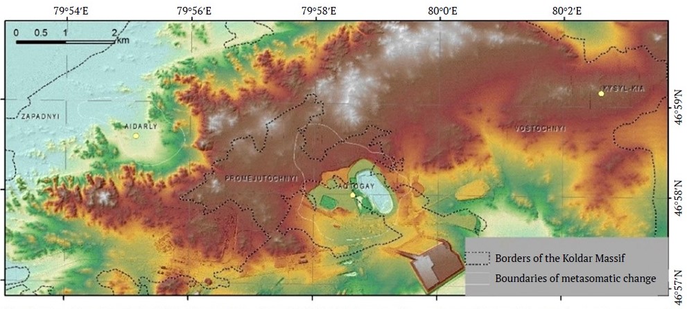
Fig. 3. Visualization of the DTM. The surface of the DTM is displayed with a color gradient with a semi-transparent overlay of a shaded terrain surface
2.2. Construction of the Residual Terrain Surface
The goal is to calculate the difference between the smoothed upper surface, connecting peaks and ridges, and the lower surface, connecting river valleys. However, at first glance, the seemingly simple task of finding a smoothed surface presents certain difficulties. This immediately rules out the possibility of using standard mathematical functions such as "Median," "Low Pass" filters, Fourier analysis, or polynomials. All of them provide a regional background, but do not allow for control of the edge elevation marks. What remains is the application of a smoothing surface constructed along the inflection points. That is, it is necessary to find extreme points, or the second derivative of the surface, and divide the obtained extreme values according to their position in the terrain. This function is implemented in the ENVI software package.
The algorithm used in the ENVI Topographic Features module to calculate channels and ridges was described by Wood4. Another option for selecting boundary elevation marks is possible as a result of calculating surfaces from a river network created in ArcMap (ArcScript5) with a specified catchment threshold. Moreover, to distinguish ridges, it is possible to use a river network constructed on the basis of inverted terrain [40].
When selecting peaks, ridges, pits, and valleys, it is important to select the correct smoothing threshold, i.e., the restriction on the selection of ridges and river valleys based on their scale characteristics. Elevation interpolation was performed using the ArcMap software package.
When processing the DTM data, we constructed smoothing surfaces based on local maxima and local minima of the terrain (Fig. 4).
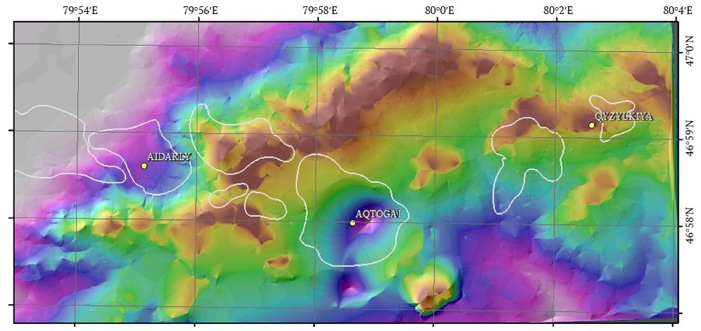
Fig. 4. Residual terrain surface – the difference between the surface constructed on the basis of local topographic maxima and the surface based on local minima. The metasomatic alteration areas are outlined.
As a result, a quantitative assessment of the elevation difference for the Aktogai ore field was obtained, which can be shown in color. The difference between the surfaces allows to distinguish local landforms and areas that differ in terms of terrain texture characteristics.
Areas of local depression in the terrain are distinguished. Areas of local depression in the terrain were obtained by subtracting the DTM values from the surface constructed based on local terrain maxima (Fig. 5).
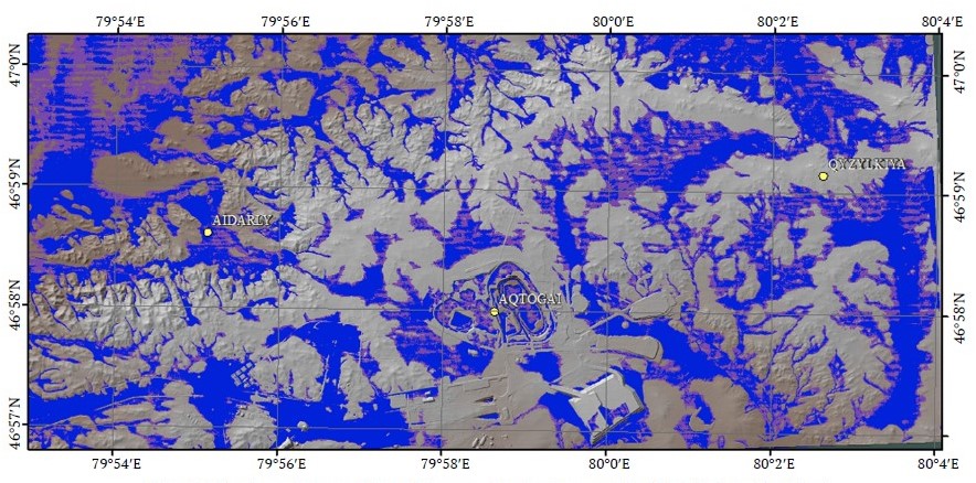
Fig. 5. Display of areas of local depression in the terrain (highlighted in blue)
4 Wood J. D. The geomorphological characterisation of digital elevation models. [PhD thesis]. University of Leicester, UK; 1996. 466 p.
5 Galang J. ArcGIS Script #13836 ArcScripts; 2005. URL: http://arcscripts.esri.com/details.asp?dbid=13836
2.2. Textural Analysis of Terrain
Texture is a set of repeating or regular variations in brightness in local areas of an image. It reflects the spatial relationships between pixels and can describe characteristics such as: uniformity; codimension; smoothness; skewness.
Textural analysis, which is widely used to analyze geological structures, can be performed using several methods.
A textural analysis was performed for the DTM, comparing the statistical dependence of pixel values in a given filter window. The surfaces of incline, curvature, local minima and local maxima, as well as entropy, uniformity, mean value, and skewness of a histogram were calculated. These methods evaluate texture based on statistical characteristics of an image: Gray-Level Co-Occurrence Matrix (GLCM). A matrix is created showing how often a pair of pixels with specific brightness values occur at a given distance and angle to each other:
The texture parameters are calculated from this matrix:
- Energy – a measure of texture uniformity
- Contrast – evaluates the differences between neighboring pixels
- Correlation – the degree of linear dependence between adjacent pixels
- Entropy – characterizes the chaotic nature of the texture
- Skewness – characterizes a clearly expressed direction.
For the matrices obtained, classification intervals were empirically selected and visualized for contrast in a color palette.
Using textural analysis provides the following advantages: increased accuracy in object classification; detection of hidden patterns that cannot be identified by analyzing spectral characteristics alone. Topographic modeling software in ENVI6 was used to analyze the surface terrain.
Combinations of RGB channels allow creating contrasting differences in terrain caused by lithological features and geological processes involved in its formation. Fig. 6 uses the most informative combination of RGB channels, where R = incline, G = shaded terrain, and B = root mean square value. The image clearly shows the lithological differences between rock types and anthropogenic changes caused by mineral extraction.
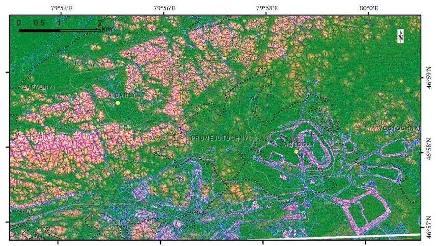
Fig. 6. RGB channel combination: R – incline, G – shaded terrain, and B – root mean square value. Intrusive complexes and anthropogenic changes are clearly distinguished
Using textural analysis, we achieve the following advantages: improving the accuracy of object classification and discovering hidden patterns that cannot be identified solely by analyzing spectral characteristics.
6 NV5 Geospatial. NV5 Geospatial Software. [Accessed: April 20, 2025] URL: https://www.nv5geospatialsoftware.com
2.3. Classification of Spectral Data
The project used various methods to identify an ore zone, which will be described in a new paper. In this work, we compare the results obtained from processing the surface terrain with the results obtained after classifying spectral data, so we present the methodology of this method here.
At the first stage, classes were selected based on objects identified as a result of processing. Thirty-seven classes were identified and used for classification using several statistical analysis methods. As a result, some lithological units and zones of secondary mineralization above ore stockworks were identified. For uncontrolled classification in a small area comprising the Aktogai and Aidarly deposits, and Promezhutochny stockworks, 30 classes were empirically selected using the K-means algorithm.
For uncontrolled classification, the number of classes was selected so that areas of known deposits were revealed. After applying the method, eight classes were selected that fall within the outline of the Aktogai deposit. The identified classes were compared with the map of metasomatic zoning compiled by Zhukov et al., 1979 (Fig. 7, b) [41], and with the map of supergene mineralization from the report of Sergiyko et al., 1980 (Fig. 7, c) [42].
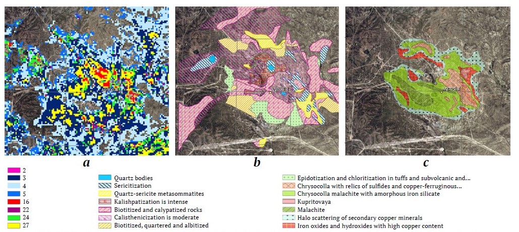
Fig. 7. Uncontrolled classification (a), map of metasomatic alteration at the Aktogai deposit (modification from: Zhukov et al., 1979) (b), map of supergene mineral associations (modification from: Sergiyko et al., 1980) (c)
With the expansion of the area to the Kyzylkiya deposit, the number of uncontrolled classes has increased to 35. The classes were converted into a mask that can be applied to matrices obtained as a result of other processing stages.
3. Findings and Discussion
In terms of their characteristics, the Aktogai, Aidarly, and Kyzylkiya deposits and the Zapadny, Promezhutochny, and Vostochny ore stockworks share common features that are typical of porphyry copper-molybdenum deposit system as a whole, and have their own distinctive features each.
The most informative findings were selected from all the processed material, and their comparative analysis with the initial information was performed.
Analysis of the terrain shows that the large Aidarly and Aktogai deposits and the Zapadny stockwork form local depressions in the terrain, large calderas comparable to the morphology of partially eroded maars. This shape is due to the formation of a system of near-stockwork fractures and the fact that hydrothermally altered and fragmented rocks in the center of the structure are more susceptible to erosion than the surrounding rocks. The intrusion of numerous dikes along fractures at the deposit led to the complication of the cauldron subsidence landforms. The elongated shapes of the Zapadny stockwork depression and the distortion of the isometric shapes of the Aidarly and Aktogai deposits indicate that the deposits were formed under compression. This is confirmed by the direction of the dikes, which develop in two main directions under conditions of transpression. The deeper erosional truncation of the Aktogai deposit leads to the flattening of the cauldron subsidence landforms, probably due to the equalization of the erodibility of host rocks and ore-bearing rocks. The image showing the depression in the terrain clearly shows that the cauldron subsidence landforms occupy the deposit open pit and extends westward toward the Promezhutochny stockwork.
The Kyzylkiya deposit and the Vostochny stockwork have a positive terrain morphology that is probably due to the fact that the upper part of the deposit has been eroded and the rock outcrop on the surface is more resistant to erosion processes.
The Promezhutochny stockwork is expressed in the terrain as a small local depression and a rise, which has probably been preserved as a result of partially manifested silicification, the manifestation of which makes the above-ore horizons more resistant to erosion.
Local depressions in the terrain (Fig. 8) emphasize the structure of ore stockworks and reflect, to some extent, the structure of the Koldar massif. For instance, in terms of its pattern, the diorite massif differs from the granodiorite massif. Depressions formed by the river system differ from those caused by superimposed stockworks and accompanying hydrothermal alteration, which include a greater number of radial and ring structures. In addition to the well-known ore stockworks, there are a number of other depressions similar to those already known.
The most interesting result of the textural analysis is the change in the skewness of the DTM surface histogram. The result was an image with contrasting distribution of values and a characteristic pattern of distinguished areas, most of which coincided with the zones of metasomatic alteration correlating with depressions in the terrain (Figs. 9, 10).
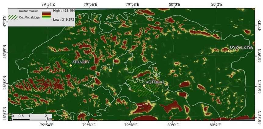
Fig. 8. Local depressions in the terrain (the difference between the digital surface model and the surface connecting local minima)
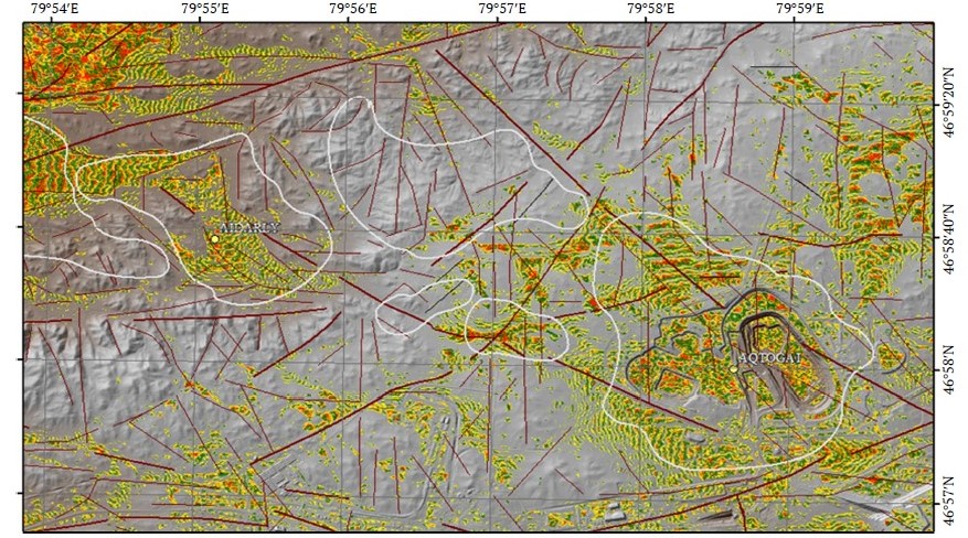
Fig. 9. DTM and superimposed mask of positive values of skewness of histogram of digital terrain surface values. The outlines indicate known areas of mineralization showing quartz-sericite-chlorite metasomatic alteration. The arrow indicates a cluster that spatially coincides with an area promising for further exploration, identified by other methods.
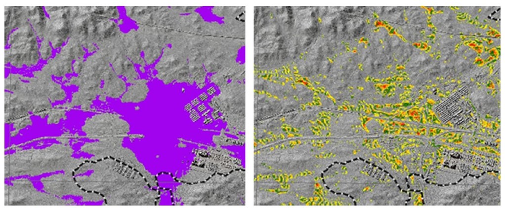
Fig. 10. Left: Area outlined by a local topographic depression; right: Positive values of skewness of the histogram of the digital terrain surface
Conclusions
In the course of processing and analysis, images were obtained that allowed the identification of tectonic disturbances (faults) and certain lithological varieties of rocks in the Koldar massif that are not reflected in existing geological maps of the ore field. The analysis of images shows that the areas of positive skewness values coincide with the general outline of metasomatic alteration developed at known deposits. The areas that stand out most are those where sericitization is more developed with a formation of supergene mineralogical association, including chrysocolla with relics of sulfides and copper-ferrous silicates. This area probably corresponds to the most fully developed metasomatism.
The areas of positive skewness confirmed the outlines of the Promezhduyuschiye and Zapadny ore stockworks and the outlines of the Aidarly deposit.
South of the Aidarly deposit, there is an anomalous cluster of the elevation histogram positive skewness values. The distinguished cluster is located at the intersection of faults and in a local depression in the terrain, similar to the location of the Aktogai and Aidarly deposits.
To identify similar areas, data on local depressions in the terrain were compared with the distribution of pixels of spectral data classes obtained by uncontrolled classification and characteristic of the Aktogai deposit outline. The characteristic areas of local depressions with manifestations of metasomatism may be promising for further exploration for ore deposits, but it should be noted that local depressions may also be caused by other geological processes, so they should be considered in conjunction with other signs of ore associations (Fig. 11).
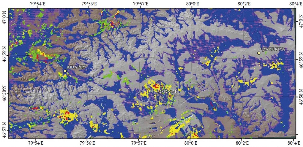
Fig. 11. Superimposition of classification results on distinguished areas of local terrain depression (DTM data substrate)
When analyzing the terrain, the individual phases of the intrusive complexes of the Koldar massif are clearly distinguished (see Figs. 4, 5). The Aidarly deposit and the Promezhutochny stockwork are associated with an intrusion that probably became exposed at a later time. It is most clearly expressed in the terrain and has a higher terrain activity index.
The Aktogai and Kyzylkiya deposits are spatially associated with an intrusion that has a characteristic appearance, a more smoothed terrain.
Based on the results of processing and analyzing satellite data, the characteristics of ore deposits were summarized according to their degree of distinguishing (Table 1).
Table 1
Comparative characteristics of ore deposits by degree of distinguishing
No. | Ore stockwork | Degree of visualization as a result of satellite data processing | |
Skewness for DGM | Cauldron subsidence | ||
1 | Aktogai Deposit | Pronounced and coincides with the outlines of intensely manifested metasomatism | A slight saucer-shaped depression in the terrain with radial branches |
2 | Aidarly deposit | Pronounced and coincides with the outlines of intensely manifested metasomatism | Distinct, with radial branches |
3 | Kyzylkiya deposit | Weakly pronounced | Not observed |
4 | Promezhutochny ore stockwork | Pronounced | Distinct, with radial branches |
5 | Zapadny ore stockwork | Stands out well | Clearly |
6 | Vostochny ore stockwork | Weakly pronounced | Not observed |
The outlines of the terrain nonuniformities at the Aktogai deposit based on the results of the processing broadly coincide with the established outlines of hydrothermally altered rocks. The areas of quartz-sericite metasomatism especially closely coincide with the known outlines.
The outlines of the terrain nonuniformities at the Aidarly deposit also coincide with the identified areas of metasomatic alteration of quartz-sericite and propylite facies. Based on the digital terrain model (DTM) processing data, the central (axial) part of the deposit was distinguished as quasi-isometric in plan view, while elongated local depressions in the caldera are indicative of the deposit formation under conditions of horizontal tectonic compression.
The spatial identification of the Kyzylkiya deposit is poorly expressed in the terrain compared to the Aktogai and Aidarly deposits and cannot be reliably distinguished when processing the DTM surface. The deposit is characterized by small-size spectral anomalies distinguished by certain methods of processing.
Promezhutochny ore stockwork cannot be clearly distinguished based on the analysis of terrain characteristics.
The Zapadny stockwork is distinguished at every stage of satellite data processing and occupies a distinctly lowered position in the terrain. Its elongated shape is probably due to its formation under compression in a north-northwest direction.
The Vostochny ore stockwork cannot be clearly distinguished.
The description shows that not all stockworks can have a characteristic terrain shape and, same to the interpretation of geophysical data, assessing the terrain shape can contribute to prospecting/exploration, but is not a sufficient indicator for the reliable identification of ore stockworks.
In the course of processing, the following additional areas can be identified, which are commeasurable to known ore deposits in terms of their spectral characteristics and landforms:
- A zone near the northern margin of the area at the intersection of the Main Koldar Fault and the North-Koldar Fault, limited by the Koldar Fault in the south. The distinguished zone is complicated by higher-order faults radiating outwards from the center of the manifestation. To some extent, the zone also manifests itself when using other processing methods. Field observations have revealed a monzonite stock, numerous veins and streaks of quartz-epidote and feldspar mineralization. Chloritization zones, as well as a strip with manifestation of malachitization are found here.
- The zone south of the Aidarly deposit in a local topographic low at the intersection of the Maly Koldar Fault and higher-order faults is distinguished by textural analysis of the DTM data. Zones of intense chlorite-carbonate metasomatism and zones of intense fracturing are observed here.
The zones of wall-rock alteration were identified using a combination of methods. Superimposition of the results enhances the contrast of the wall-rock alteration halos, and the areas identified should subsequently be compared with the results of geophysical surveys and a comprehensive geochemical survey.
We recommend analyzing the terrain morphology as an additional measure. When combined, all these methods allow for the most successful solution of forecasting problems: identifying areas that are similar in their spectral characteristics to known ore deposits and indirectly assessing their position relative to the surface. The areas may be promising for further exploration and should be verified by field observations.
References
1. Eggers M. J. Engineering geological modelling for pit slope design in the porphyry copper-gold deposits of Southeast Asia. In: Dight P. M. (ed.) APSSIM 2016: Proceedings of the First Asia Pacific Slope Stability in Mining Conference. Australian Centre for Geomechanics, Perth; 2016. Pp. 49–82. https://doi.org/10.36487/ACG_rep/1604_0.4_Eggers
2. Seib N., Kley J., Torizin J., et al. Identification of volcanic forms in a digital terrain model of the West Eifel. Zeitschrift der Deutschen Gesellschaft für Geowissenschaften. 2008;159:657–670. https://doi.org/10.1127/1860-1804/2008/0159-0657
3. Grohmann C. H., Riccomini C., Alves F. M. SRTM-based morphotectonic analysis of the Poços de Caldas Alkaline Massif, southeastern Brazil. Computers & Geosciences. 2007;33(1):10–19. https://doi.org/10.1016/j.cageo.2006.05.002
4. John D. A., Ayuso R. A., Barton M. D., et al. Porphyry copper deposit model. USGS Scientific Investigations Report, 2010–5070–B, 169 р.
5. Acocella V. Understanding caldera structure and development: An overview of analogue models compared to natural calderas. Earth-Science Reviews. 2007;85(3–4):125–160. https://doi.org/10.1016/j.earscirev.2007.08.004
6. Németh K., Cronin S. J. Syn- and post-eruptive erosion in tropical climate tephra ring (West Ambrym, Vanuatu). Geomorphology. 2007;86(1–2):115–130. https://doi.org/10.1016/j.geomorph.2006.08.016
7. Németh K. Long-term erosion-rate calculation in the Waipiata Volcanic Field (New Zealand). Géomorphologie: Relief, Processus, Environnement. 2001;7(2):137–152
8. Németh K. Calculation of long-term erosion in Central Otago, New Zealand, based on erosional remnants of maar/tuff rings. Zeitschrift für Geomorphologie. 2003;47(1):29–49. https://doi.org/10.1127/zfg/47/2003/29
9. Seib N., Kley J., Büchel G. Identification of maars and volcanic landforms in the West Eifel Volcanic Field using DTM data. International Journal of Earth Sciences. 2013;102:875–891. https://doi.org/10.1007/S00531-012-0829-5
10. Seib N., Kley J. Problems of residual surface modelling for geological applications. In: Proceedings of the Kolmogorov Readings. Moscow, Russia; 2010. Pp. 146–151.
11. Şengör A. M. C., Natal’in B. A. & Burtman V. S. Evolution of the Altaid tectonic collage and Palaeozoic crustal growth in Eurasia. Nature. 1993;364:299–307. https://doi.org/10.1038/364299a0
12. Windley B. F., Alexeiev D., Xiao W., et al. Tectonic models for accretion of the Central Asian Orogenic Belt. Journal of the Geological Society. 2007;164(1):31–47. https://doi.org/10.1144/0016-76492006-022
13. Seltmann R., Kröner A., Kovach V., et al. Reassessment of continental growth during the accretionary history of the Central Asian Orogenic Belt. Gondwana Research. 2014;25(1):103–125. https://doi.org/10.1016/j.gr.2012.12.023
14. Shen P., Pan H., Hattori K., et al. Large Paleozoic and Mesozoic porphyry deposits in the Central Asian Orogenic Belt: Geodynamic settings, magmatic sources, and genetic models. Gondwana Research. 2018;58:161–194. https://doi.org/10.1016/j.gr.2018.01.010
15. Seedorff E., Dilles J. H., Proffett J. M., et al. Porphyry deposits: Characteristics and origin of hypogene features. Economic Geology, One Hundredth Anniversary Volume. 2005;251–298. https://doi.org/10.5382/AV100.10
16. Simmons S. F., White N. C., John D. A. Epithermal precious and base metal deposits. Economic Geology, One Hundredth Anniversary Volume. 2005;485–522.
17. Yermolov P. V., Portnov V. S., Makat D. K. Age and geodynamics of Central Kazakhstan carbon ore copper provinces. Naukovyi Visnyk Natsionalnoho Hirnychoho Universytetu. 2017;(6):5–15.
18. Li C., Shen P., Pan H., et al. Geology and ore-forming fluid evolution of the Aktogai giant porphyry Cu deposit, Kazakhstan. Journal of Asian Earth Sciences. 2018;165:192–209. https://doi.org/10.1016/j.jseaes.2018.07.009
19. Buslov M. M., Fujiwara Y., Iwata K., Semakov N. N. Late Palaeozoic–early Mesozoic geodynamics of Central Asia. Gondwana Research. 2004;7(3):791–808. https://doi.org/10.1016/S1342-937X(05)71064-9
20. Filippova I. B., Bush V. A., Didenko A. N. Middle Paleozoic subduction belts: the leading factor in the formation of the Central Asian fold-and-thrust belt. Russian Journal of Earth Sciences. 2001;3(6):405–426. https://doi.org/10.2205/2001ES000073
21. Cao M. J., Li G. M., Qin K. Z., et al. Assessing the magmatic affinity and petrogenesis of granitoids at the giant Aktogai porphyry Cu deposit, Central Kazakhstan. American Journal of Science. 2016;316:614–668. https://doi.org/10.2475/07.2016.02
22. Poletaev A. I., Krasnovikov A. T., Nurtuganov B. N., Timofeeva S. N. Geological structure and age of the Koldar intrusive. Izvestiya Akademii Nauk Kazakhskoi SSR, Seriya Geologicheskaya. 1987;(6): 3–13.
23. Mao J. W., Pirajno F., Lehmann B., et al. Distribution of porphyry deposits in the Eurasian continent and their tectonic settings. Journal of Asian Earth Sciences. 2014;79(B):576–584. https://doi.org/10.1016/j.jseaes.2013.09.002
24. Shen P., Pan H.D., Xiao W.J., et al. Two geodynamic–metallogenic events in the Balkhash (Kazakhstan) and the West Junggar (China): Carboniferous porphyry Cu and Permian greisen W-Mo mineralization. International Geology Review. 2013;55(13):1660–1687. https://doi.org/10.1080/00206814.2013.792500
25. Li C., Shen P., Pan H. Mineralogy of the Aktogai giant porphyry Cu deposit in Kazakhstan: Insights into the fluid composition and oxygen fugacity evolution. Ore Geology Reviews. 2018;95:899–916. https://doi.org/10.1016/j.oregeorev.2018.03.027
26. Seltmann R., Shatov V., Yakubchuk A. Mineral deposits database and thematic maps of Central Asia. London: CERCAMS, Natural History Museum; 2004. 117 p.
27. Zvezdov V. S., Migachev I. F., Girfanov M. M. Porphyry copper deposits of the CIS and models of their formation. Ore Geology Reviews. 1993;7(6):511–549. https://doi.org/10.1016/0169-1368(93)90013-O
28. Burbank D. W. Rates of erosion and their implications for exhumation. Mineralogical Magazine. 2002;66(1):25–52. https://doi.org/10.1180/0026461026610014
29. Sobel E. R., Oskin M., Burbank D., Mikolaichuk A. Exhumation of basement uplifts: Kyrgyz Range, using fission track thermochronology. Tectonics. 2006;25(2). https://doi.org/10.1029/2005TC001809
30. Corbett G. J., Leach T. M. Southwest Pacific gold-copper systems: Structure, alteration, and mineralisation. Society of Economic Geologists; 1998. https://doi.org/10.5382/SP.06
31. Skirrow R. G., Huston D. L., Mernagh T. P., et al. Critical commodities for a high-tech world: Australia’s supply potential. Geoscience Australia, Canberra; 2013.
32. Carten R. B., White W. H., Stein H. J. High-grade granite-related molybdenum systems: classification and origin. Mineral Deposit Modeling. 1993; 40:521–554.
33. Heidrick T. L., Title S. R. Fracture and dike patterns in Laramide plutons and their structural and tectonic implications. In: Titley S. R. (Ed.) Advances in Geology of Porphyry Copper Deposits. Southwestern North America. Tucson: University of Arizona Press; 1982. Pp. 73–92.
34. Sillitoe R. H. Porphyry copper systems. Economic Geology. 2010; 105:3–41. https://doi.org/10.2113/gsecongeo.105.1.3
35. Tosdal R. M., Richards J. P. Magmatic and structural controls on porphyry copper ± Mo ± Au deposits. Reviews in Economic Geology. 2001; 14:157–181.
36. Gustafson L. B., Hunt J. P. The porphyry copper deposit at El Salvador, Chile. Geological Bulletin of China. 1975;21:768–776.
37. Bostjančić I., Gulam V., Pollak D., Frangen T. Comparative analysis of slope and relief energy for small-scale landslide susceptibility mapping: insights from Croatia. Remote Sensing; 2025; 17:2142. https://doi.org/10.3390/rs17132142
38. Zograbian L. N., Gevorkian F. S. "Relief energy", its mapping and significance in the erosion process. Izvestiya of the Academy of Sciences of the Armenian SSR, Earth Sciences. 1969;(4):80–86. (In Russ.)
39. Mark D. M. Geomorphometric parameters: A review and evaluation. Geografiska Annaler: Series A. 1975;57(3–4):165–177.
40. Chernova I. Yu., Khasanov D. I., Zharkov I. Ya., et al. Detection and study of the zones of the latest crustal movements using GIS tools. Arc Review. 2005;(1):6–7. (In Russ.)
41. Zhukov N. M., Filimonova L. E., Vizigina V. G. Metasomatizes and hypogene mineralization of the Aktogay porphyry copper deposit. Almaty; 1979. 230 p.
42. Sergiyko, Yu.A., et al. Report on the detailed exploration of the Aktogay copper-porphyry deposit with reserve estimation as of 01.01.1980. Alma-Ata; 1980. (In Russ.)
About the Authors
N. SeibKazakhstan
Nadine Seib – PhD (Earth Sci.), Senior Geologist; Senior Research Fellow, School of Earth Sciences
Almaty;
Ust-Kamenogorsk
Scopus ID 8417022400
Yu. Belov
Kazakhstan
Yu. Belov – Senior Geologist
Astana
N. Zimanovskaya
Kazakhstan
Natalya A. Zimanovskaya – PhD (Geology and Mineral Exploration), Associate Professor, Senior Researcher, Center of Competence and Technology Transfer in Geology and Mining
Ust-Kamenogorsk
G. Orazbekova
Kazakhstan
Gulizat B. Orazbekova – PhD (Geology and Mineral Exploration), Lecturer, Department of Automation and Information Technologies
Semey
A. Tretyakova
Kazakhstan
Aizhan Tretyakova - Senior Geologist
Almaty
A. Muratova
Kazakhstan
Assem M. Muratova – PhD student (Geology and Mineral Exploration)
Ust-Kamenogorsk
Scopus ID 58574678800
I. Kassenov
Kazakhstan
Issatay Kassenov – Chief GIS Specialist
Astana
Review
For citations:
Seib N., Belov Yu., Zimanovskaya N., Orazbekova G., Tretyakova A., Muratova A., Kassenov I. Analysis of a digital terrain model for solving geological problems by the example of Aktogai ore field. Mining Science and Technology (Russia). 2025;10(3):245-261. https://doi.org/10.17073/2500-0632-2025-06-422


