Scroll to:
GIS modeling of a Cenozoic strata structure in Brest region for forecasting and evaluation of non-metallic deposits
https://doi.org/10.17073/2500-0632-2024-03-230
Abstract
To date, considerable experience has been accumulated in solving the problems of forecasting and evaluation of minerals, primarily fossil fuels and ore minerals. Virtually any such forecast requires the use of computer modeling methods, which today have become an integral part of geological industry, operating with large data sets. But despite such significant successes in solving the problem of natural (mineral) resources forecasting using up-to-date information technologies, scientific and methodological approaches to modeling the subsoil of territories where commonly occurring mineral resources (COMR) are concentrated are still insufficiently developed. Due to insufficient funding, this type of resources is often overlooked, despite its important socio-economic significance for the development of local industry of various ranks in regions. COMR are also important for the territory of the Brest region of Belarus. The development of the mineral resource base of this region due to the peculiarities of its geological structure (the territory is formed by a thick strata of Cenozoic sediments) is associated with commonly occurring types of raw materials. Therefore, scientific research aimed at modeling the geological structure of Cenozoic sediments in the Brest region to assess the prospects for dicovering new deposits of non-metallic minerals in the region is very relevant. The purpose of this work is to create a digital geological model of the Cenozoic sediments of the Brest region as a basis for forecasting the new COMR deposits, being most accessible for development in the region, and assessing the prospects for their development. Objectives: to systematize data on the geological structure of the Brest region; to create a digital geological model of the Cenozoic strata in the Brest region; to develop an approach to the grouping of the region's lands according to their acceptability for the development of COMR deposits; to develop a scheme of involvement of the predicted COMR deposits of the Brest region in development. Study subject: Cenozoic sediments in the Brest region. Methods: computer modeling, geoinformation, approximation, cartographic, classification, expert review. Results: a new, targeted scientific and methodological approach to the geological modeling of the subsoil and non-metallic mineral deposits in the Brest region was proposed. The regional-level digital geological model created on its basis makes it possible to perform primary forecasting of COMR deposits confined to the Cenozoic sediments, as well as to assess the acceptability of involvement of the identified deposits in development.
Keywords
For citations:
Bogdasarov M.A., Mayevskaya A.N., Petrov D.O., Sheshko N.N. GIS modeling of a Cenozoic strata structure in Brest region for forecasting and evaluation of non-metallic deposits. Mining Science and Technology (Russia). 2024;9(4):328-340. https://doi.org/10.17073/2500-0632-2024-03-230
GIS modeling of a Cenozoic strata structure in Brest region for forecasting and evaluation of non-metallic deposits
Introduction
To date, a huge amount of research has been carried out to solve the problems of forecasting and evaluation of oil and gas deposits. The growing interest in these raw materials is determined by the permanent growth of demand and prices for them. In addition, such studies are characterized by large amounts of both governmental and private investments. At the same time, commonly occurring mineral resources (COMR), which are of great socio-economic importance for the development of local industry in regions, are quite often undeservedly neglected.
COMR should to solve one of the most important problems for regions of different ranks – to meet the needs of the construction industry with local raw materials. That is why the systematic geological study of such resources is seen as a very relevant area of research at the present stage. Geological studies of the raw materials base of COMR are also important for the territory of the Brest region (the Republic of Belarus), which (its subsoil) is geologically composed of a thick sedimentary strata, mainly Cenozoic. The most accessible for development deposits of COMR in the region and in the country as a whole are genetically connected with this strata.
Detailed studies of Cenozoic sediments in the Brest region, first of all the Quaternary strata, were carried out since the middle of the XIX century and were connected with the construction of railroads and industrial enterprises, which created a demand for construction raw materials [1]. Today, numerous deposits of construction materials (clays, loams, sands and sand-and-gravel rocks, etc.) have already been explored in the region. A significant portion of such deposits are being developed. The rest serve as reserve bases for businesses in the region.
Despite the achieved successes in the creation and development of the raw material base of COMR in the Brest region, the problem of forecasting and assessment of such resources continues to be an urgent problem here. This is primarily due to the need to update the results accumulated by the predecessors using the latest (most complete) geological drilling data. At the present stage, this problem can be solved most effectively with the use of computer modeling methods. Updating of data on COMR reserves/resources in the region will allow geologists to plan further study of subsoil for the development of mineral resource base (MRB) of Brest region and create a qualitative basis for providing interested organizations with information on promising deposits of construction raw materials.
Based on the above, the aim and objectives of the present study can be formulated.
The purpose of the study is to create a digital geological model of the Cenozoic sediments of the Brest region as a basis for forecasting the new most accessible for development COMR deposits in the region and assessing the prospects for their development.
Research objectives:
- to systematize the accumulated data on the geological structure of the Brest region;
- to create a digital geological model of the Cenozoic strata in the Brest region;
- to develop an approach to grouping the lands of the Brest region according to their acceptability for the development of COMR deposits;
- to develop a reasonable scheme of involvement of predicted COMR deposits in the Brest region in development.
The study subject is Cenozoic sediments in the Brest region.
Source materials
The database of drilling exploration maturity of the Brest region, compiled by the authors on the basis of materials provided by the State Enterprise "Scientific and Production Center for Geology" and the State Scientific Institution "Institute of Nature Management of the National Academy of Sciences of Belarus" served as the source data for the present study implementation.
The described database contains information on more than 5500 wells that were drilled at different times in the region. For each horizon penetrated by a particular well, more than 20 characteristics are given here. Among them the most significant for the purpose of the present research are the following: location, depth of occurrence, stratigraphic description, lithological description, absolute elevations of the upper and lower contacts, thickness of rocks.
A characteristic feature of the described well network is the unevenness of its distribution over the territory of the Brest region. As can be seen in Fig. 1, the concentration of wells in the western part of the region is very high, while in the eastern part, on the contrary, it is extremely low. This feature has had a significant impact on the development of a digital geologic model of the Cenozoic sediments of the region.
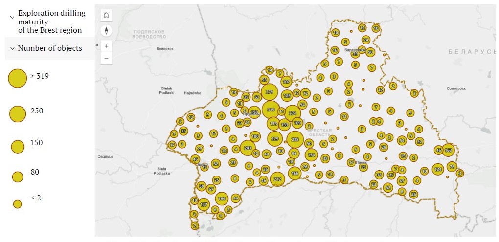
Fig. 1. Distribution of drilling wells over the territory of the Brest region
Research techniques
Currently, there are a wide variety of techniques devoted to solving the problem of geologic computer modeling for mineral deposit prediction. At the same time, most of these approaches, which have proven their practical effectiveness, are focused on the creation of models with respect to the forecast of ore and fossil fuels deposits. To a lesser extent, these approaches are focused on building subsoil models for COMR forecasting. This is due not only to the smaller amount of funding for research in the field of forecasting of commonly occurring raw materials, but also to the specificity of specialized GIS programs. A large number of tools presented in such GIS were developed in the context of oil exploration tasks, where the data network is dense and uniform. Applying them to a heterogeneous and sparse network of data (most inherent in COMR) is often infeasible. That is why the creation of models of subsoil structure for forecasting non-metallic minerals quite often requires the use of specially developed algorithms, methods, and technologies.
Taking into account the above-mentioned, as well as the experience accumulated in domestic and foreign practice in the field of geological modeling [2–4], to achieve the purpose of this study, the author's method of forecasting and evaluation of COMR deposits occurring in Cenozoic sediments of the Brest region [5] is proposed. The scheme assumes realization of forecasting and evaluation on the basis of digital geological model of the given strata. The main blocks of the proposed methodology are shown in Fig. 2. In the following, we will elaborate on each of these blocks in more detail.
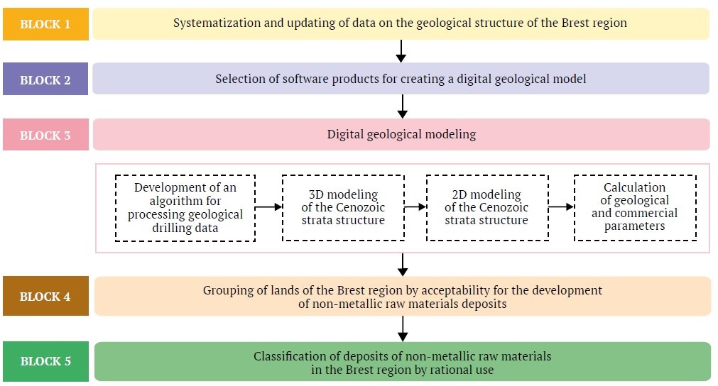
Fig. 2. Structural and logical scheme of the methodology of forecasting and evaluation of COMR deposits in the Brest region
Block 1. Systematization and updating of data on the geological structure of the Brest region. In view of the fact that the main objective of the study is to forecast new COMR deposits in the region, the first stage of the study, according to the authors, should be the systematization of the accumulated extensive material on the geological structure of the Brest region. After all, it is the geological structure that is the key factor determining the regularities of the region's mineral raw material base location and its specificity. In addition, it is impossible to build a correct geologic model without understanding the specifics of the geologic structure.
The direct implementation of this block included: 1 – collection and generalization of numerous materials on the geological structure of this territory; 2 – clarification of data obtained in the historical researches of this territory on the basis of the author's set of horizon-by-horizon isopachyte schematic maps.
Block 2. Selection of software products for creating a digital geological model. In view of the fact that the goal set in the paper can be achieved most effectively with the use of information products, this block became a significant part of the study.
As practice shows, a variety of GIS packages are used as a software basis for geological modeling, which can be combined into two groups [6]: subsoil use GIS (Rock-works, GMS, Surfer, Petrel, etc.) and general geographic GIS (ArcGIS, MapInfo, QGIS, etc.).
The use of such programs as GIS Petrel and GIS ArcGIS 10.5 was considered for creation of digital geological model of the studied region. However, since Petrel package was developed for the use in oil exploration and production sector, where drilling data network is very dense and uniform, it was not possible to apply it to model creation for the purpose of COMR deposit prediction. Therefore, preference was given to the ArcGIS 10.5 general geographic system.
In addition to the selection of GIS as the main modeling platform, this stage included the selection of additional software tools that extend the basic functionality of the selected GIS package. The use of the following means was justified: MS Access DBMS,Microsoft Excel, Blender 3D computer graphics software, Wolfram Mathematica computer algebra system.
Block 3. Digital geological modeling. The block under consideration is the key block of the study and the longest in terms of implementation time. It included the following steps:
- development of an algorithm for processing the materials presented in the exploration drilling database in order to identify erroneous data present in them;
- creation of a three-dimensional digital geologic model of the region [7];
- converting the three-dimensional model into a two-dimensional format;
- calculation of the most significant geological and commercial parameters(vertical thickness of sediments, overburden thickness, overburden ratio);
- construction of a set of prognostic-mineralogenic schematic maps reflecting data on the patterns of distribution and promising areas of the most significant types of non-metallic raw materials in the investigated territory in terms of thickness.
Block 4. Grouping of lands of the Brest region by acceptability for the development of non-metallic raw materials deposits. Inclusion of a block allowing to take into account the type of land of the deposit location area in the evaluation scheme is connected with the specifics of COMR mining. The development of these types of raw materials is usually carried out by open-pit mining, which leads to negative impact on environmental components. This, in turn, increases the cost of developing such resources due to the need for subsequent compensation for damage, primarily related to the degradation of different types of land.
In the Brest region, the use of such a block is also significant due to the fact that here the extraction of construction raw materials is often carried out through the development of on-farm quarries, that makes commercialization of the disturbed lands extremely problematic .
The final result produced by the block under consideration was the authors' proposed approach to grouping of the Brest region lands in terms of the feasibility of open-pit mining [8].
Block 5. Classification of deposits of non-metallic raw materials in the Brest region by rational use. The final block of the proposed methodology was the classification of COMR deposits of the Brest region identified during the modeling by their acceptability for development. The classification procedure was carried out on the basis of complexing raster coverages, reflecting geological and commercial parameters for each deposit, and calculated weighting coefficients, characterizing the acceptability of the groups of lands of the Brest region selected at stage 4 for COMR development. The algorithm of deposit classification is described in more detail in [9].
Results and their discussion
A complex analysis of the geological structure of the Brest region territory as a key factor determining the regularities of formation of the region raw-materials base and its specificity was carried out. A brief characterization of the main features of the region territory geological structure is given below.
The territory of the Brest region is located in the western part of East European paleoplatform. Taking into account the depth the crystalline basement top, the following tectonic elements were distinguished within the basement: Podlyassko-Brestsky Depression (eastern part), Polesskaya Anticline, Pripyatsky Trough (western part), Mikashevichsko-Zhitkovichsky nose of the crystalline basement, Ivatsevichsky buried nose of the Belarusian Anticlise, Lukovsko-Ratnovsky gorst, Volynskaya monocline of the Volyno-Azovsky plate. The sedimentary cover sediments are ubiquitous and united into structural complexes, successively alternating in the section of the formation series and separated by nondepositional hiatuses. These complexes correspond to the main tectonic stages of the territory's development: Gothic, Lower Baikaskyl, Upper Baikalsky, Caledonian, Hercynian, Cimmerian-Alpine.
The most widespread among the rocks of the platform cover of the studied region are Cenozoic sediments, primarily Quaternary ones. The accumulation of the Cenozoic sediments occurred during three geologic periods with different paleogeographic conditions that influenced the nature of sedimentation and the present-day structure of the sedimentary cover of the region.
The Paleogene system sediments occupy significant areas within the region. Absolute elevations of their base vary from 30–40 m in the north and northwest to 150 m in the south and southwest. The sediments thickness in most of the region is 20–30 m.
The Neogene system sediments within the Brest region occupy extensive areas, overlying the Paleogene and underlying Quaternary. They occur at absolute elevations of 30–150 m, reaching maximum elevations in the southwest. Their average thickness is 15–20 m.
The Quaternary sediments are widespread in the study area and superpose the formations of older geological systems. Their thickness varies from a few tens to 240 m.
Since the greatest prospects for the development of raw-materials base in the region are associated with the Cenozoic sediments, a set of horizon-to-horizon isopachyte schematic maps was produced to clarify the specifics of their structure. One of them is shown as an example in Fig. 3.
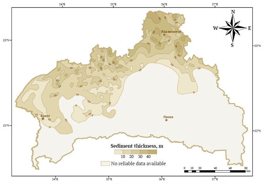
Fig. 3. Isopachyte schematic map of the Sozh subhorizon of the Pripyatsky horizon (Q2pr1 sz) of the Quaternary system in the territory of the Brest region
A digital geological model of Cenozoic sediments in the Brest region was developed. It represents a concentrated system of data on structural, lithologic, and mining and geological features of the structure of the Cenozoic strata in the region [7].
Due to the multi-layered structure of the data used for modeling, the model was initially generated in a volumetric form. The three-dimensional model was realized on the basis of the author's algorithm executed with the use of an independently developed module in the C++ programming language. This algorithm is based on constructions based on Voronoi diagram. As can be seen in Fig. 4, the volumetric model consists of a set of convex polyhedra in three-dimensional space. The adjacent groups of these polyhedrons represent sedimentary rock deposit bodies that may be considered as potential for development of COMR in the region.
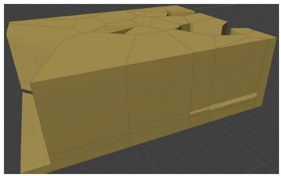
Fig. 4. Example of the generated volumetric model reflecting the distribution of sand deposits in the Quaternary sediments in the territory of Zhabinka district of the Brest region, author's algorithm
Since the construction of the three-dimensional model was based in some parts on a sparse network of wells, it differs to a great extent from the classical volumetric models, which are presented in the scientific literature devoted to modeling of oil reservoirs. This led to the necessity to carry out the procedure of its approximation and formation of a two-dimensional model, which is also the most familiar from the viewpoint of analysis for profile specialists. The algorithm for transforming a three-dimensional model into a two-dimensional format is described in detail in [7].
On the whole, the created two-dimensional model represents data sets structured as an ArcGIS geodatabase files: 1 – vector point layers obtained during numerical processing of the volumetric model "sliced" into layers; 2 – raster covers for each of the 19 rock types; 3 – classes of polygonal objects reflecting preliminary boundaries of COMR deposits, their thicknesses, thicknesses of overlying sediments, and occurrence elevations.
The two-dimensional model served as a basis for creating a basic set of digital prognostic-mineralogenic schematic maps of the region, which was performed for such rock types as sands, rubbly-gravel-sandy rocks (sand-gravel-rubbly rocks), clays, clay loams and sandy loams, and peat. It is these rocks that are the most significant in terms of thickness and areal representation within the study territory. An example of the map from the described set is shown in Fig. 5.
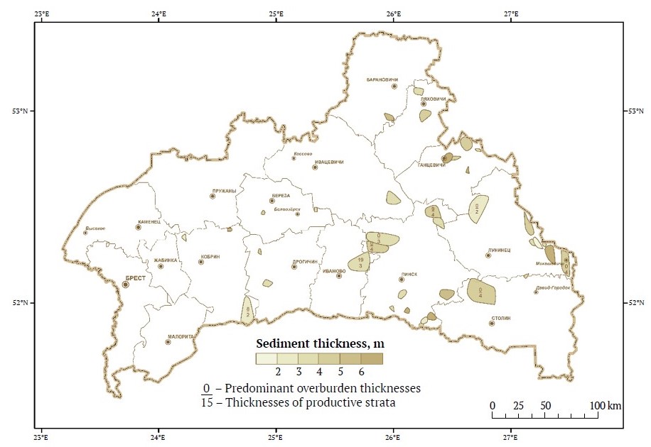
Fig. 5. Schematic map of regularities of location and forecasting of peat deposits in Cenozoic sediments in the Brest region
The approach to grouping of the Brest region lands according to their acceptability for development of COMR deposits is proposed. When classifying the lands, consideration was given to: 1 – legal norms regulating the possibility of using lands of different types in the Republic of Belarus for quarrying1; 2 – approaches to grouping of lands according to their acceptability for development of COMR deposits, used in the works of other researchers2 [10, 11]; 3 – the approach to grouping of lands according to the degree of anthropogenic impact on natural landscapes, used in the work of B.I. Kochurov [12].
The land groups are the result of systematization of a set of land subtypes3 [13] in the Brest region land information system database. A total of six land groups were identified due to the grouping (Table 1).
Table 1
Grouping of the Brest region lands in terms of acceptability for the development of construction raw materials deposits
Code | Land group | Land subtype |
1 | Land most acceptable for the development of COMR | Other unused land; sands devoid of vegetation; ravines and scour holes; bars; pits |
2 | Land acceptable for the development of COMR | Derelict land; meadow; meadow (bushy); meadow (waterlogged); meadow (waterlogged, bushy); improved meadow; unforested |
3 | Land allowable for the development of COMR | Arable; greenhouses, hot houses; orchards; berry fields; plantations; fruit crop nurseries; forests; plantings; forest belts; field, forest roads; clearings |
4 | Land restricted for the development of COMR | Lands disturbed during mining and extraction of minerals; lands disturbed during peat and sapropel extraction; lands disturbed during construction works; burnt-out peatlands; former agricultural lands contaminated with radionuclides; lands under reclamation construction; lands in the stage of fertility restoration; dumps and spoil heaps; pits/quarries and other facilities at the stage of mineral extraction; lands at the stage of peat and sapropel extraction; active construction sites and other sites at the stage of construction; lands used for waste storage; animal burial sites. |
5 | Land extremely restricted for the development of COMR | Country roads; improved roads – right-of-way (carriageway); improved roads – slopes; cattle runs; railroads – right-of-way; railroads – slopes; railroads – platforms; other transportation lanes; lands under pipelines; bridges, overpasses, trestles; squares; streets and passages; carriageways of streets; parks, squares, boulevards, other green areas; lawns and flowerbeds; mounds; cemeteries; lands provided to citizens for collective gardening; homestead lands; yards (without division into industrial and residential buildings; open warehouses; pens; residential buildings; non-residential buildings; light-type buildings; other buildings and structures; silage pits |
6 | Land prohibited for the development of COMR | Rivers; canals and ditches; lakes; reservoirs and ponds; dams; weirs; under-edges; swamps |
To ensure the possibility of using the developed classification when assessing the acceptability of the development of COMR deposits in the Brest region, weighting coefficients were calculated for each group of lands based on the method of hierarchy analysis T. Saati [13, 14].
Based on the land grouping and the calculation of weighting coefficients , a digital raster model was created (Fig. 6), reflecting the acceptability of the distinguished groups of lands in the region for the development of deposits of construction raw materials.
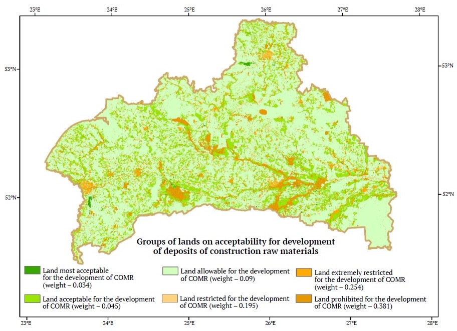
Fig. 6. Raster model reflecting the acceptability of different groups of lands in the Brest region for the development of deposits of construction raw materials
1 National Legal Internet Portal of the Republic of Belarus. Land Code of the Republic of Belarus. URL: https://pravo.by/document/?guid=12551&p0=H12200195 [Accessed February 29, 2024]; National Legal Internet Portal of the Republic of Belarus. Subsoil Code of the Republic of Belarus. URL: https://pravo.by/document/?guid=3871&p0=Hk0800406 [Accessed February 29, 2024]; Belarus Legal Forum. Draft Resolution of the Council of Ministers of the Republic of Belarus "On the procedure of location, development, reclamation and accounting of on-farm quarries". URL: https://forumpravo.by/publichnoe-obsuzhdenie-proektov-npa/forum15/16239 [Accessed February 29, 2024].
2 Lyutyagin D.V. Geological and economic substantiation of involvement in development of deposits of commonly occurring mineral resources.[Ph.D. thesis in Economics]. М.: 2006, 28 p. (in Russ.).
3 National Legal Internet Portal of the Republic of Belarus. Land Information System of the Republic of Belarus. Procedures for creating, maintaining (operating and updating). URL: https://pravo.by/document/?guid=12551&p0=W22137315&p1=1&p5=0 [Accessed February 29, 2024].
The scheme of involvement of predicted COMR deposits in the Brest region into development was developed. As a result of creating a raster model reflecting the acceptability of different groups of land in the Brest region to the development of COMR deposits, it became possible to substantiate the rational sequence of involving the construction raw materials deposits of the studied region in development. For this purpose, a procedure of complexing several types of raster surfaces was carried out in ArcGIS 10.5 software package: 1 – rasters of thicknesses of the identified promising areas of local raw materials; 2 – rasters of overburden thicknesses over the identified deposits; 3 – raster showing the availability of the Brest region lands for COMR development [9].
Two types of schematic map sets were generated based on the complexing results:
- 1) schematic maps providing a general concept of the acceptability of development of the identified non-metallic raw materials in the region. An example of such a map is shown in Fig. 7;
- 2) schematic maps providing a detailed concept of the acceptability of development of each individual deposit. An example of such a map is shown in Fig. 8.
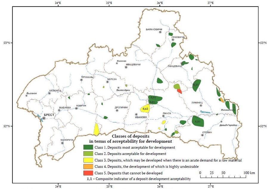
Fig. 7. Schematic map of peat deposits in the Brest region classified in terms of development prospects
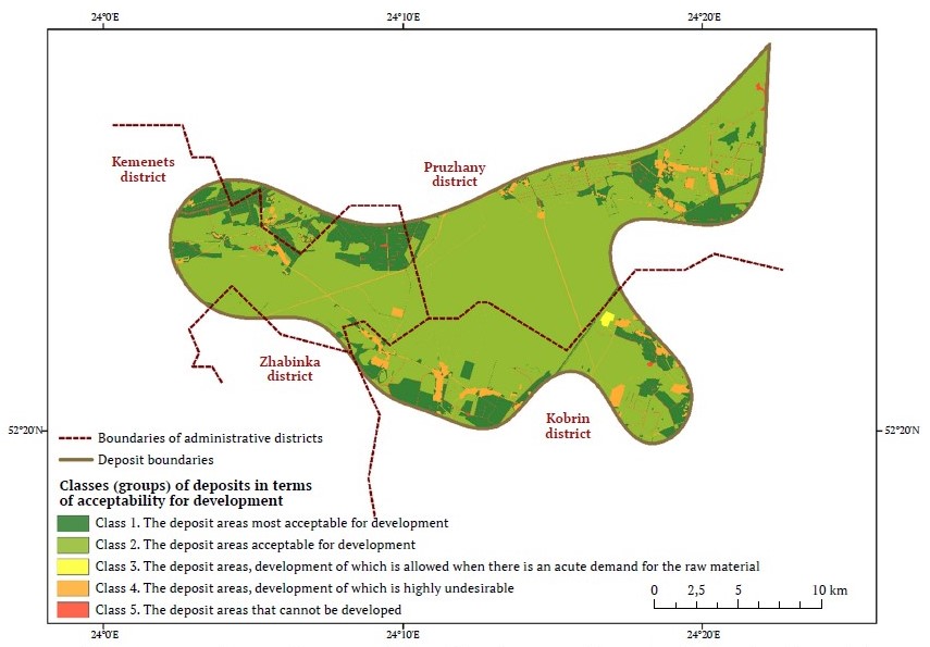
Fig. 8. Schematic map reflecting the acceptability of development of an individual sand and gravel deposit within the Brest region
As can be clearly seen in both figures, all the deposits are grouped into five classes on the schematic maps:
1) the most acceptable for development deposits, which occur close the surface, have significant thicknesses of productive strata, and are confined to unused or poorly used agricultural and forest lands;
2) acceptable for development deposits, the stripping ratio of which is predominantly equal to one, confined to agricultural and forest lands with high intensity of use;
3) Deposits, development of which is allowed when there is an acute demand for a raw material, mainly occurring under disturbed lands, with stripping ratio equal to or exceeding 1;
4) Deposits, development of which is highly undesirable, occurring under developed lands with stripping ratio exceeding 1;
5) Deposits, development of which is impossible, occurring under water bodies and swamps, with the overburden thickness significantly (two or more times) exceeding the productive strata thickness.
At the same time, it should be noted that the presented approach to justification of the feasibility of a deposit development taking into account the status of lands should be considered as preliminary. The final decision on the acceptability of developing a particular deposit should be made only after a detailed study of the area where it is located. This will allow a more objective assessment of the impact of the planned works on the natural environment components.
Practical application of the research results
The results obtained during the implementation of the research described in this paper have already found their application both in the educational and production process. In particular, the developed algorithm of geological survey data processing and a set of tools designed to automate its work are used in the educational process and research work by the students of the Department of Urban and Regional Development of the Faculty of Natural Science of the Brest State University named after A.S. Pushkin, as well as by the students of the Department of Environmental Management of the Faculty of Engineering Systems and Ecology of the Brest State Technical University. This is confirmed by the relevant adoption deeds.
The created sets of isopachite schematic maps, prognostic-mineralogenic schematic maps, schematic maps of acceptability of involvement of non-metallic raw materials deposits in the Brest region into development are introduced and used in the study of Cenozoic sediments of the region in the laboratory of recent geodynamics and paleogeography of the Institute of Nature Management of the National Academy of Sciences of Belarus, as well as in the Quaternary geology department of the branch Institute of Geology of the Republican Unitary Enterprise "Scientific and Production Center for Geology".
The economic significance of the obtained results can be assessed in the case of making appropriate management decisions on the development of the region mineral resources base and consists in the availability of relevant and verifiable information on the geological structure of the territory, significantly facilitating both solving the problems of further prospecting for new mineral deposits and the subsoil use for the purposes unrelated to development of mineral resources.
Areas of further research
The authors see the prospects for further research on the forecast and assessment of COMR deposits in the Brest region in supplementing the proposed methodology with a block for assessment of deposit accessibility. In this paper we propose to understand accessibility as the proximity / remoteness of deposits in relation to raw material consumption clusters and in relation to the available transportation infrastructure. The authors suggest assessing accessibility using the following criteria:
- remoteness of deposits in relation to transportation lanes;
- remoteness of deposits in relation to consumption clusters [5].
The last criterion can be analyzed in two ways:
- assessment of remoteness relative to settlements as areas of potential construction, expansion or repair of various construction facilities, as well as areas acting as places of labor force concentration;
- assessment of remoteness relative to specialized industrial enterprises, taking into account their demand for certain types of construction raw materials.
Conclusion
The study for the first time presents the results of the forecast and assessment of deposits of mineral construction raw materials concentrated in the Cenozoic sediments of the Brest region with the use of computer modeling methods. The main results of the conducted work can be summarized in the following conclusions:
- On the basis of the materials accumulated by predecessors and a series of the author's digital horizon-by-horizon isopachite maps, the analysis of the geological structure of the studied region was performed. The data obtained during the analysis provided the possibility of visual assessment of the correctness of the results obtained at different stages of creating a digital geological model of the Cenozoic sediments in the Brest region.
- A three-dimensional digital geological model of the Cenozoic sediments in the Brest region was developed. An author's algorithm based on the application of the Voronoi diagram has been developed for its creation. Due to the fact that the created volumetric model differs significantly from classical two-dimensional models, the algorithm includes the possibility of approximating it by switching to a two-dimensional model. The obtained two-dimensional model gives a holistic view of the geological structure of the Cenozoic sediments in the region and serves as a basis for the creation of a series of digital schematic maps reflecting the features of spatial tracking of the COMR deposits in the region identified in the course of modeling.
- An approach to land grouping in the Brest region was developed. On its basis, all lands in the region were grouped into six groups (classes) in terms of their acceptability for COMR extraction. For each group of lands weight coefficients were calculated and a digital raster model was created, which served as a basis for the classification of COMR deposits in the Brest region according to the "rational sequence" of development.
- The approach to classification of COMR deposits in the Brest region identified in the course of modeling in terms of their acceptability for development is proposed. It is based on taking into account such characteristics as the thickness of a deposit, the overburden thickness above the deposit, and the weight value of the land groups under which the deposit is located. As a result of the classification, a set of schematic maps reflecting the acceptability of the region’s COMR deposits for development was created. Attributive information is attached to each deposit on the generated digital schematic maps. The obtained sets of the schematic maps and the associated databases of the attributive information may be of interest to local territorial authorities in the development of a regional action plan for the study, development, and rational use of deposits of local raw materials.
References
1. Lukashev K. I. et al. History of geological sciences in the Byelorussian SSR. Minsk: Nauka i Tekhnika Publ.; 1978. 272 p. (In Russ.)
2. Zakrevsky K. Е. Geological 3D modeling. Moscow: IPTs Maska LLC Publ.; 2009. 376 p. (In Russ.)
3. Poklonov V. I., Semyonov F. V., Ivanov S. K. Creation of forecasting mathematical model of regularities of quartz sands placement for construction works in the territory of the Republic of Mari El. Prospect and Protection of Mineral Resources. 2015;(7):23–26 (In Russ.)
4. Boissonnat J-D., Nullans S. Reconstruction of Geological Structures from Heterogeneous and Sparse Data. The 4th ACM international workshop on Advances in geographic information systems. 1996;3069:3–24. URL: https://inria.hal.science/inria-00073623
5. Bogdasarov M. A., Maevskaya A. N., Sheshko N. N. Methodical specifics of forecasting and evaluating commonly occurring mineral resources. Prospect and Protection of Mineral Resources. 2023;(3):45–52. https://doi.org/10.53085/0034-026X_2023_03_45
6. Petin A. N., Vasiliev P. V. Geoinformatics in rational subsoil use. Belgorod: BelSU Publ.; 2011. 268 p. (In Russ.)
7. Mayeuskaya H. M., Bahdasarau M. A., Piatrou D. A., Sheshka M. M. Geological and genetic modelling of the Cenozoic deposits of the Brest region using information technologies. Journal of the Belarusian State University. Geography and Geology. 2023;(1):107–118. (In Russ.) URL: https://elib.bsu.by/handle/123456789/298810
8. Mayevskaya A. N., Bogdasarov M. A., Sheshko N. N. Ranking of the land fund of the administrative districts of the Brest Region according to the acceptability to the development of deposits of construction raw materials. Natural Resources. 2022;(2):45-56. (In Russ.) URL: https://priroda.belnauka.by/jour/article/view/140
9. Mayevskaya A. N., Bogdasarov M. A., Sheshko N. N. Justification of schemes of rational use of deposits of non-metallic raw materials in Brest region. Prirodopol'zovanie. 2023;(1):135–150 (In Russ.)
10. Peshkova G. Yu. Express-evaluation of clay deposits mining effectiveness on the base of economic-geological criteria (using Leningrad region as an example). Corporate governance and innovative economic development of the North: Bulletin of the Research Center of Corporate Law, Management and Venture Capital of Syktyvkar State University. 2016;(1):121–128.
11. Cheremisina E. N., Nikitin A. A. Applying geoinformation systems in nature use. Geoinformatika. 2006;(3):5–20. (In Russ.)
12. Kochurov B. I. Ecodiagnosis and sustainable development. Moscow: INFRA-M Publ.; 2016. 362 p. (In Russ.)
13. Saati T. Analytical Planning. Systems Organization. Moscow: Radio i Svyaz' Publ.; 1991. 224 p. (In Russ.)
14. Saaty T. Decision Making. Hierarchy Analysis Method. Moscow: Radio i Svyaz' Publ.; 1993. 278 p. (In Russ.)
About the Authors
M. A. BogdasarovBelarus
Maksim A. Bogdasarov – Corresponding Member of the National Academy of Sciences of Belarus, Professor, Dr.Sci. (Geol. and Mineral.), Vice-Rector for Science, Professor of the Department of Urban and Regional Development, Professor of the Department of Biological and Chemical Technologies
Brest
Scopus ID 57191968270, ResearcherID HPG-0293-2023
A. N. Mayevskaya
Belarus
Anna N. Mayevskaya – Cand. Sci. (Geol. and Mineral.), Senior Lecturer at the Department of urban and regional development
Brest
D. O. Petrov
Belarus
Dmitry O. Petrov – Cand. Sci. (Eng.), Associate Professor of the Department of Electronic Computing Machines and Systems, Faculty of Electronic Information Systems
Brest
N. N. Sheshko
Belarus
Nikolay N. Sheshko – Cand. Sci. (Eng.), Associate Professor, Head of the Research Department, Associate Professor of the Department of Environmental Management, Faculty of Engineering Systems and Ecology
Brest
Scopus ID 57214638269
Review
For citations:
Bogdasarov M.A., Mayevskaya A.N., Petrov D.O., Sheshko N.N. GIS modeling of a Cenozoic strata structure in Brest region for forecasting and evaluation of non-metallic deposits. Mining Science and Technology (Russia). 2024;9(4):328-340. https://doi.org/10.17073/2500-0632-2024-03-230


